
Oderstausee-Brocken
A cycling route starting in Sankt Andreasberg, Lower Saxony, Germany.
Overview
About this route
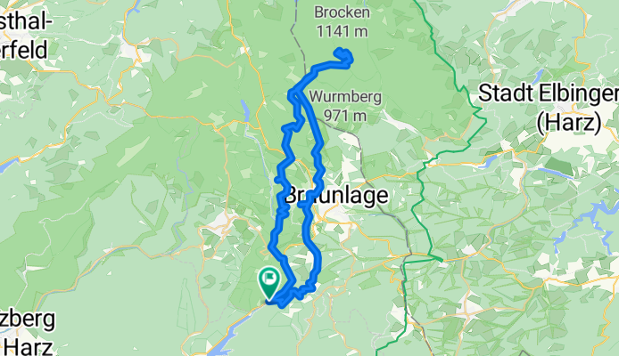
The starting point is a parking lot near the Odertaler sawmill, then it goes up a bit steeply for a short while. Due to construction work, we had to push a bit. It continues moderately upward to the Silberteich. Then always further up to the Brocken, where, logically, the gradient increases. I don’t need to say much about the Brocken itself. In good weather, there’s a mega view, and there’s gastronomy available, though it doesn’t really impress me. The descent is almost the same route, passing the Brocken Teufelskanzel (viewpoint), then the path forks, and after a short climb (we had to push), we passed the Achtermannshöhe. There you have to climb up again to get a super view of the surroundings (Brocken, Wurmberg etc.). The descent continues to the Hahnekleeklippen (viewpoint into the Oder valley). After that, it’s just rolling back to the starting point.
- -:--
- Duration
- 46.7 km
- Distance
- 905 m
- Ascent
- 904 m
- Descent
- ---
- Avg. speed
- ---
- Max. altitude
Route quality
Waytypes & surfaces along the route
Waytypes
Track
38.8 km
(83 %)
Path
2.8 km
(6 %)
Surfaces
Paved
9.3 km
(20 %)
Unpaved
36.9 km
(79 %)
Gravel
29 km
(62 %)
Asphalt
7.9 km
(17 %)
Route highlights
Points of interest along the route

Point of interest after 10.2 km
Silberteich

Point of interest after 14.9 km
Rastplatz

Point of interest after 23.3 km
Restaurant

Point of interest after 23.4 km
Brockenstein
Point of interest after 24.3 km
Teufelskanzel auf dem Brocken
Point of interest after 29.5 km
Wanderhütte

Point of interest after 33.4 km
Achtermannshöhe

Point of interest after 37 km
Hahnekleeklippen
Continue with Bikemap
Use, edit, or download this cycling route
You would like to ride Oderstausee-Brocken or customize it for your own trip? Here is what you can do with this Bikemap route:
Free features
- Save this route as favorite or in collections
- Copy & plan your own version of this route
- Sync your route with Garmin or Wahoo
Premium features
Free trial for 3 days, or one-time payment. More about Bikemap Premium.
- Navigate this route on iOS & Android
- Export a GPX / KML file of this route
- Create your custom printout (try it for free)
- Download this route for offline navigation
Discover more Premium features.
Get Bikemap PremiumFrom our community
Other popular routes starting in Sankt Andreasberg
 Sonnenberg-Herz Mountains
- Distance
- 33.3 km
- Ascent
- 458 m
- Descent
- 458 m
- Location
- Sankt Andreasberg, Lower Saxony, Germany
 20170714_090522.gpx
- Distance
- 82.8 km
- Ascent
- 380 m
- Descent
- 577 m
- Location
- Sankt Andreasberg, Lower Saxony, Germany
 St Andreasberg - Brocken - St Andreasberg
- Distance
- 69.8 km
- Ascent
- 1,292 m
- Descent
- 1,295 m
- Location
- Sankt Andreasberg, Lower Saxony, Germany
 RTF - Grosse Ostharztour
- Distance
- 113 km
- Ascent
- 1,223 m
- Descent
- 1,247 m
- Location
- Sankt Andreasberg, Lower Saxony, Germany
 Harztour 03.05.2010
- Distance
- 52.3 km
- Ascent
- 1,170 m
- Descent
- 1,170 m
- Location
- Sankt Andreasberg, Lower Saxony, Germany
 Góry Harc 07 września 2011
- Distance
- 86.5 km
- Ascent
- 0 m
- Descent
- 0 m
- Location
- Sankt Andreasberg, Lower Saxony, Germany
 MTB Sankt Andreasberg Rundkurs
- Distance
- 56.9 km
- Ascent
- 1,068 m
- Descent
- 1,070 m
- Location
- Sankt Andreasberg, Lower Saxony, Germany
 Harztour 01.05.2010
- Distance
- 54 km
- Ascent
- 1,428 m
- Descent
- 1,428 m
- Location
- Sankt Andreasberg, Lower Saxony, Germany
Open it in the app