

NL Rondje Meinweg-Roerdal
A cycling route starting in Sint Odiliënberg, Limburg, The Netherlands.
Overview
About this route
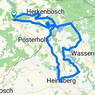
This is a circular route which mainly leads through the Nationaal Park De Meinweg. The track is 47 km long and starts in Sint Odilienberg. First you go to Vlodrop, and pass the Effelder Waldsee in Germany. Then, the track leads you to Dalheim-Rödgen and Oberkrüchten. In Meinfeld you cross the Dutch border again and enter the National Park De Meinweg. You return to Sint Odilienberg by passing Rothenbach and Herkenbosch.
- -:--
- Duration
- 47.4 km
- Distance
- 141 m
- Ascent
- 140 m
- Descent
- ---
- Avg. speed
- ---
- Max. altitude

Route quality
Waytypes & surfaces along the route
Waytypes
Quiet road
18 km
(38 %)
Track
13.7 km
(29 %)
Surfaces
Paved
22.3 km
(47 %)
Unpaved
8.1 km
(17 %)
Asphalt
20.8 km
(44 %)
Gravel
6.6 km
(14 %)
Continue with Bikemap
Use, edit, or download this cycling route
You would like to ride NL Rondje Meinweg-Roerdal or customize it for your own trip? Here is what you can do with this Bikemap route:
Free features
- Save this route as favorite or in collections
- Copy & plan your own version of this route
- Sync your route with Garmin or Wahoo
Premium features
Free trial for 3 days, or one-time payment. More about Bikemap Premium.
- Navigate this route on iOS & Android
- Export a GPX / KML file of this route
- Create your custom printout (try it for free)
- Download this route for offline navigation
Discover more Premium features.
Get Bikemap PremiumFrom our community
Other popular routes starting in Sint Odiliënberg
 Sint-Odiliënberg - Vlodrop - Orsbeck - Lieck - Waldfeucht - Maria-Hoop - Montfort - Sint-Odiliënberg
- Distance
- 42.8 km
- Ascent
- 111 m
- Descent
- 107 m
- Location
- Sint Odiliënberg, Limburg, The Netherlands
 Roerroute (ANWB Route midden limburg 13)
- Distance
- 43.8 km
- Ascent
- 72 m
- Descent
- 69 m
- Location
- Sint Odiliënberg, Limburg, The Netherlands
 Schepersheuvel 26, Sint Odiliënberg naar Schaapsweg 19, Sint Odiliënberg
- Distance
- 51.1 km
- Ascent
- 184 m
- Descent
- 187 m
- Location
- Sint Odiliënberg, Limburg, The Netherlands
 Rondje Meinweg-Roerdal
- Distance
- 47.4 km
- Ascent
- 153 m
- Descent
- 153 m
- Location
- Sint Odiliënberg, Limburg, The Netherlands
 NL Rondje Meinweg-Roerdal
- Distance
- 47.4 km
- Ascent
- 141 m
- Descent
- 140 m
- Location
- Sint Odiliënberg, Limburg, The Netherlands
 rur wassenberg
- Distance
- 55.3 km
- Ascent
- 282 m
- Descent
- 283 m
- Location
- Sint Odiliënberg, Limburg, The Netherlands
 Om de Meinweg
- Distance
- 82.1 km
- Ascent
- 172 m
- Descent
- 175 m
- Location
- Sint Odiliënberg, Limburg, The Netherlands
 Roerroute (ANWB Route midden limburg 13) CLONED FROM ROUTE 131847
- Distance
- 43.9 km
- Ascent
- 53 m
- Descent
- 53 m
- Location
- Sint Odiliënberg, Limburg, The Netherlands
Open it in the app