

Pic de Nore
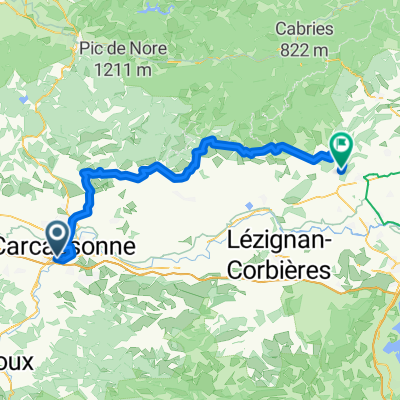
A cycling route starting in Carcassonne, Occitanie, France.
Overview
About this route
- -:--
- Duration
- 44.6 km
- Distance
- 1,256 m
- Ascent
- 466 m
- Descent
- ---
- Avg. speed
- 902 m
- Max. altitude

Route quality
Waytypes & surfaces along the route
Waytypes
Road
9.4 km
(21 %)
Access road
2.2 km
(5 %)
Surfaces
Paved
25 km
(56 %)
Asphalt
25 km
(56 %)
Undefined
19.6 km
(44 %)
Continue with Bikemap
Use, edit, or download this cycling route
You would like to ride Pic de Nore or customize it for your own trip? Here is what you can do with this Bikemap route:
Free features
- Save this route as favorite or in collections
- Copy & plan your own version of this route
- Sync your route with Garmin or Wahoo
Premium features
Free trial for 3 days, or one-time payment. More about Bikemap Premium.
- Navigate this route on iOS & Android
- Export a GPX / KML file of this route
- Create your custom printout (try it for free)
- Download this route for offline navigation
Discover more Premium features.
Get Bikemap PremiumFrom our community
Other popular routes starting in Carcassonne
 EV3.3 Carcassonne-Narbonne
- Distance
- 124.9 km
- Ascent
- 24 m
- Descent
- 173 m
- Location
- Carcassonne, Occitanie, France
 EV3.3 Carcassonne-Narbonne
- Distance
- 113.9 km
- Ascent
- 31 m
- Descent
- 181 m
- Location
- Carcassonne, Occitanie, France
 Narbonne-Carcassonne
- Distance
- 63.6 km
- Ascent
- 247 m
- Descent
- 340 m
- Location
- Carcassonne, Occitanie, France
 BVCC Carcassonne to Port Camargue
- Distance
- 176.8 km
- Ascent
- 263 m
- Descent
- 376 m
- Location
- Carcassonne, Occitanie, France
 KAB-T2.1, 101km
- Distance
- 80.7 km
- Ascent
- 1,254 m
- Descent
- 1,304 m
- Location
- Carcassonne, Occitanie, France
 Carcassonne to Durban-Corbières
- Distance
- 61.1 km
- Ascent
- 739 m
- Descent
- 775 m
- Location
- Carcassonne, Occitanie, France
 Rue du Plo, Carcassonne to Impasse Condorcet, Argeliers
- Distance
- 71.3 km
- Ascent
- 155 m
- Descent
- 260 m
- Location
- Carcassonne, Occitanie, France
 2013 Ride Day 23 - Carcassonne Circle through Conques-sur-Orbiel, Salsigne, Cuxac-Cabardès, and Pennautier
- Distance
- 59 km
- Ascent
- 596 m
- Descent
- 595 m
- Location
- Carcassonne, Occitanie, France
Open it in the app