

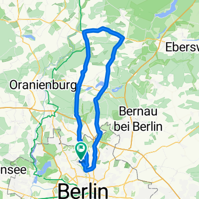
200 km Uckermark-Runde
A cycling route starting in Wilhelmsruh, Land Berlin, Germany.
Overview
About this route
Große Runde durch die Uckermark, teilweise auf Fernradwegen, erst auf dem Radweg Berlin-Kpenhagen, dann Berlin-Usedom und Uckermark-Radweg
- -:--
- Duration
- 225.4 km
- Distance
- 736 m
- Ascent
- 715 m
- Descent
- ---
- Avg. speed
- 92 m
- Avg. speed
Route quality
Waytypes & surfaces along the route
Waytypes
Busy road
86.2 km
(38 %)
Quiet road
47 km
(21 %)
Surfaces
Paved
184 km
(82 %)
Unpaved
20.5 km
(9 %)
Asphalt
168.2 km
(75 %)
Ground
14.9 km
(7 %)
Continue with Bikemap
Use, edit, or download this cycling route
You would like to ride 200 km Uckermark-Runde or customize it for your own trip? Here is what you can do with this Bikemap route:
Free features
- Save this route as favorite or in collections
- Copy & plan your own version of this route
- Sync your route with Garmin or Wahoo
Premium features
Free trial for 3 days, or one-time payment. More about Bikemap Premium.
- Navigate this route on iOS & Android
- Export a GPX / KML file of this route
- Create your custom printout (try it for free)
- Download this route for offline navigation
Discover more Premium features.
Get Bikemap PremiumFrom our community
Other popular routes starting in Wilhelmsruh
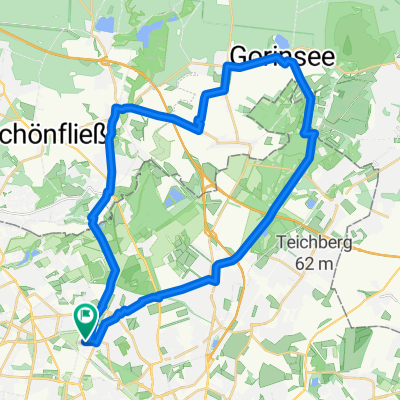 Gorinsee und zurück
- Distance
- 34.9 km
- Ascent
- 69 m
- Descent
- 70 m
- Location
- Wilhelmsruh, Land Berlin, Germany
 Pankow - Wutzsee
- Distance
- 87.1 km
- Ascent
- 132 m
- Descent
- 129 m
- Location
- Wilhelmsruh, Land Berlin, Germany
 200 km Uckermark-Runde
- Distance
- 225.4 km
- Ascent
- 736 m
- Descent
- 715 m
- Location
- Wilhelmsruh, Land Berlin, Germany
 Von Alt-Reinickendorf entlang des alten Grenzstreifen
- Distance
- 16.7 km
- Ascent
- 424 m
- Descent
- 424 m
- Location
- Wilhelmsruh, Land Berlin, Germany
 Berlin - Florenz
- Distance
- 1,606.6 km
- Ascent
- 4,533 m
- Descent
- 4,525 m
- Location
- Wilhelmsruh, Land Berlin, Germany
 Pankow - Wandlitzer See
- Distance
- 65.3 km
- Ascent
- 113 m
- Descent
- 110 m
- Location
- Wilhelmsruh, Land Berlin, Germany
 Wilhelmsruh Radfahren
- Distance
- 11.1 km
- Ascent
- 8 m
- Descent
- 8 m
- Location
- Wilhelmsruh, Land Berlin, Germany
 Rennrad Hausrunde
- Distance
- 123.9 km
- Ascent
- 240 m
- Descent
- 226 m
- Location
- Wilhelmsruh, Land Berlin, Germany
Open it in the app