

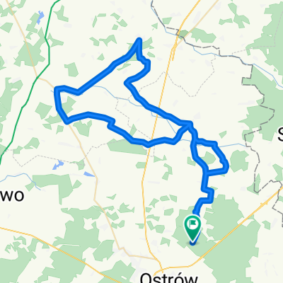
Poborze-Jelonki-Wąsewo-Długosiodło-Brańszczyk-Brok-Małkinia-Nieskórz-Króle-Podborze
A cycling route starting in Ostrów Mazowiecka, Masovian Voivodeship, Poland.
Overview
About this route
Poborze-Jelonki-Wąsewo-Długosiodło-Brańszczyk-Brok-Małkinia-Nieskórz-Król-Podborze
- -:--
- Duration
- 120.8 km
- Distance
- 178 m
- Ascent
- 177 m
- Descent
- ---
- Avg. speed
- ---
- Max. altitude

Route quality
Waytypes & surfaces along the route
Waytypes
Road
54.3 km
(45 %)
Quiet road
31.4 km
(26 %)
Surfaces
Paved
101.5 km
(84 %)
Unpaved
13.3 km
(11 %)
Asphalt
101.5 km
(84 %)
Unpaved (undefined)
7.2 km
(6 %)
Continue with Bikemap
Use, edit, or download this cycling route
You would like to ride Poborze-Jelonki-Wąsewo-Długosiodło-Brańszczyk-Brok-Małkinia-Nieskórz-Króle-Podborze or customize it for your own trip? Here is what you can do with this Bikemap route:
Free features
- Save this route as favorite or in collections
- Copy & plan your own version of this route
- Split it into stages to create a multi-day tour
- Sync your route with Garmin or Wahoo
Premium features
Free trial for 3 days, or one-time payment. More about Bikemap Premium.
- Navigate this route on iOS & Android
- Export a GPX / KML file of this route
- Create your custom printout (try it for free)
- Download this route for offline navigation
Discover more Premium features.
Get Bikemap PremiumFrom our community
Other popular routes starting in Ostrów Mazowiecka
 Podborze-Jelonki-Wąsewo-Goworowo-Czerwin-Piski-Gniazdowo-Lubotyń-Szumowo-Króle-Podborze
- Distance
- 108.6 km
- Ascent
- 205 m
- Descent
- 207 m
- Location
- Ostrów Mazowiecka, Masovian Voivodeship, Poland
 Dojaz do Zaręby Jartuzy na pętlę Szumowo
- Distance
- 14.3 km
- Ascent
- 54 m
- Descent
- 58 m
- Location
- Ostrów Mazowiecka, Masovian Voivodeship, Poland
 Trip from Komorowo to Brok (and back again)
- Distance
- 19.5 km
- Ascent
- 52 m
- Descent
- 82 m
- Location
- Ostrów Mazowiecka, Masovian Voivodeship, Poland
 Do mamy na kawkę
- Distance
- 102.6 km
- Ascent
- 387 m
- Descent
- 410 m
- Location
- Ostrów Mazowiecka, Masovian Voivodeship, Poland
 16 Ostrow-Bialystock
- Distance
- 103.2 km
- Ascent
- 197 m
- Descent
- 175 m
- Location
- Ostrów Mazowiecka, Masovian Voivodeship, Poland
 Podborze-Lubotyń-Seroczyn-Czerwin-Piski-Gniazdowo-Lubotyń-Podbiele-Podborze
- Distance
- 62.4 km
- Ascent
- 100 m
- Descent
- 97 m
- Location
- Ostrów Mazowiecka, Masovian Voivodeship, Poland
 Długosiodło - tam/powrót 70km
- Distance
- 70.1 km
- Ascent
- 86 m
- Descent
- 84 m
- Location
- Ostrów Mazowiecka, Masovian Voivodeship, Poland
 Poborze-Jelonki-Wąsewo-Długosiodło-Brańszczyk-Brok-Małkinia-Nieskórz-Króle-Podborze
- Distance
- 120.8 km
- Ascent
- 178 m
- Descent
- 177 m
- Location
- Ostrów Mazowiecka, Masovian Voivodeship, Poland
Open it in the app