Pleißeradweg von Markkleeberg nach Regis-Breitingen
A cycling route starting in Markkleeberg, Saxony, Germany.
Overview
About this route
Mit der S-Bahn bis Markkleeberg
Sehenswürdigkeiten: Schloßpark Rötha Kirche Rötha (Silbermann-Orgel) Lagune Kahnsdorf Aussichtspunkt Tagebau Schleenhain (bei Deutzen) Rückfahrt mit der S-Bahn ab Regis-Breitingen- -:--
- Duration
- 28.5 km
- Distance
- 95 m
- Ascent
- 50 m
- Descent
- ---
- Avg. speed
- ---
- Avg. speed
Route quality
Waytypes & surfaces along the route
Waytypes
Path
10.4 km
(37 %)
Quiet road
7.8 km
(27 %)
Surfaces
Paved
21.9 km
(77 %)
Unpaved
1.4 km
(5 %)
Asphalt
13.6 km
(48 %)
Paving stones
8 km
(28 %)
Route highlights
Points of interest along the route
Point of interest after 8.9 km
Hochbrücke über die Pleiße
Point of interest after 10 km
Schlosspark Rötha
Point of interest after 10.5 km
Kirche Rötha
Point of interest after 23.9 km
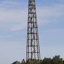
Aussichtspunkt Tagebau Schleehain
Continue with Bikemap
Use, edit, or download this cycling route
You would like to ride Pleißeradweg von Markkleeberg nach Regis-Breitingen or customize it for your own trip? Here is what you can do with this Bikemap route:
Free features
- Save this route as favorite or in collections
- Copy & plan your own version of this route
- Sync your route with Garmin or Wahoo
Premium features
Free trial for 3 days, or one-time payment. More about Bikemap Premium.
- Navigate this route on iOS & Android
- Export a GPX / KML file of this route
- Create your custom printout (try it for free)
- Download this route for offline navigation
Discover more Premium features.
Get Bikemap PremiumFrom our community
Other popular routes starting in Markkleeberg
- Cosputener See, Zwenkauer See, Ziegeleiweg, Markkleeberg nach Ziegeleiweg, Markkleeberg
- Distance
- 36.6 km
- Ascent
- 57 m
- Descent
- 105 m
- Location
- Markkleeberg, Saxony, Germany
- Roundtrip Cospudener See
- Distance
- 12.1 km
- Ascent
- 31 m
- Descent
- 29 m
- Location
- Markkleeberg, Saxony, Germany
- Neuseenland
- Distance
- 88.3 km
- Ascent
- 187 m
- Descent
- 189 m
- Location
- Markkleeberg, Saxony, Germany
- Leipzig-Markkleeberg
- Distance
- 56.1 km
- Ascent
- 112 m
- Descent
- 101 m
- Location
- Markkleeberg, Saxony, Germany
- Markkleeberg-Cosputener und Zwenkauer See
- Distance
- 34.4 km
- Ascent
- 89 m
- Descent
- 88 m
- Location
- Markkleeberg, Saxony, Germany
- Markleeberger See - Störmthaler See
- Distance
- 33.2 km
- Ascent
- 119 m
- Descent
- 128 m
- Location
- Markkleeberg, Saxony, Germany
- Seen-Rundfahrt CLONED FROM ROUTE 324751
- Distance
- 78.3 km
- Ascent
- 145 m
- Descent
- 153 m
- Location
- Markkleeberg, Saxony, Germany
- Cospudener See
- Distance
- 11 km
- Ascent
- 8 m
- Descent
- 9 m
- Location
- Markkleeberg, Saxony, Germany
Open it in the app