

Dobra :D
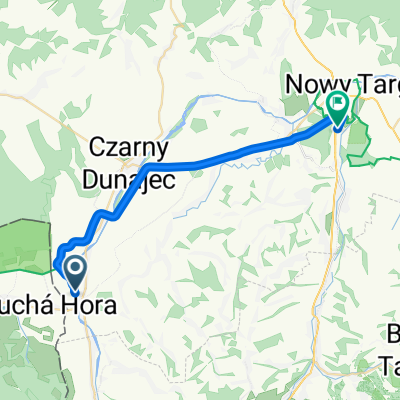
A cycling route starting in Czarny Dunajec, Lesser Poland Voivodeship, Poland.
Overview
About this route
Fajna traska, kilka cięższych podjazdów :D
- -:--
- Duration
- 75 km
- Distance
- 941 m
- Ascent
- 940 m
- Descent
- ---
- Avg. speed
- ---
- Max. altitude
Route quality
Waytypes & surfaces along the route
Waytypes
Road
39 km
(52 %)
Quiet road
3.7 km
(5 %)
Surfaces
Paved
63.7 km
(85 %)
Unpaved
0.7 km
(1 %)
Asphalt
63.7 km
(85 %)
Ground
0.7 km
(1 %)
Undefined
10.5 km
(14 %)
Continue with Bikemap
Use, edit, or download this cycling route
You would like to ride Dobra :D or customize it for your own trip? Here is what you can do with this Bikemap route:
Free features
- Save this route as favorite or in collections
- Copy & plan your own version of this route
- Sync your route with Garmin or Wahoo
Premium features
Free trial for 3 days, or one-time payment. More about Bikemap Premium.
- Navigate this route on iOS & Android
- Export a GPX / KML file of this route
- Create your custom printout (try it for free)
- Download this route for offline navigation
Discover more Premium features.
Get Bikemap PremiumFrom our community
Other popular routes starting in Czarny Dunajec
 CHOCHOŁÓW-Dookoła Tatr 4-5-07-2015
- Distance
- 196.4 km
- Ascent
- 1,858 m
- Descent
- 1,860 m
- Location
- Czarny Dunajec, Lesser Poland Voivodeship, Poland
 Historicko-kultúrno-prírodná Cesta okolo Tatier, Suchá Hora do Rynek 33, Nowy Targ
- Distance
- 25 km
- Ascent
- 79 m
- Descent
- 251 m
- Location
- Czarny Dunajec, Lesser Poland Voivodeship, Poland
 Tour de Tatry Słowackie
- Distance
- 156.6 km
- Ascent
- 1,445 m
- Descent
- 1,415 m
- Location
- Czarny Dunajec, Lesser Poland Voivodeship, Poland
 Cyklovýlet okolo Tatier 4. den
- Distance
- 73.9 km
- Ascent
- 1,271 m
- Descent
- 1,247 m
- Location
- Czarny Dunajec, Lesser Poland Voivodeship, Poland
 Trasa do Szaflarska
- Distance
- 25.1 km
- Ascent
- 76 m
- Descent
- 266 m
- Location
- Czarny Dunajec, Lesser Poland Voivodeship, Poland
 From Czarny Dunajec to Czarny Dunajec Gmina
- Distance
- 9.6 km
- Ascent
- 46 m
- Descent
- 76 m
- Location
- Czarny Dunajec, Lesser Poland Voivodeship, Poland
 Wycieczka do Zuberca i na Rohace
- Distance
- 38.9 km
- Ascent
- 700 m
- Descent
- 402 m
- Location
- Czarny Dunajec, Lesser Poland Voivodeship, Poland
 Chochołów pętla 002
- Distance
- 11.1 km
- Ascent
- 82 m
- Descent
- 85 m
- Location
- Czarny Dunajec, Lesser Poland Voivodeship, Poland
Open it in the app