- 157.2 km
- 706 m
- 706 m
- Niederaula, Hesse, Germany
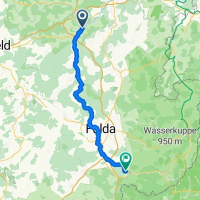
Vom Fuldatal ins Haunetal und an den Rand der Rhön
A cycling route starting in Niederaula, Hesse, Germany.
Overview
About this route
At the start, the route climbs noticeably on a quiet asphalt road up to just below the Mengshäuser Kuppe. Here follows a short unpaved section, which can also be passed with a road bike. Then there is a descent to Kruspis. With gentle undulations, we reach Holzheim. Next is a stronger descent into the Haune valley to Neukirchen. Here a winding road twists up to Oberstoppel on the edge of the Rhön and the Hessian Kegelspiel. On a side route, it slopes slightly down to Steinbach. We pass through the town and follow the L3380 to Rothenkirchen. Shortly before, we join the B 27 and follow the old B 27 to the 'Sennhütte'. Here we follow the busy road for a few meters before turning left onto the ascent to Wehrda. Now we enjoy low car traffic again. Before entering the town, we pass Schloss Wehrda, which is privately owned. Across open fields, we gently climb through the villages of Schletzenrod and Wetzlos. Here, a particularly strong headwind can make progress difficult. After Wetzlos, the road rises slightly again before descending at 8% into the Fulda valley. At the entrance to Solms, we turn immediately right to the destination Mengshausen. A few kilometers remain, mostly flat, along the edge of the Fulda back to the starting point.
- -:--
- Duration
- 35.9 km
- Distance
- 637 m
- Ascent
- 637 m
- Descent
- ---
- Avg. speed
- ---
- Max. altitude
created this 11 years ago
Route quality
Waytypes & surfaces along the route
Waytypes
Track
8.6 km
(24 %)
Quiet road
5 km
(14 %)
Surfaces
Paved
17.2 km
(48 %)
Unpaved
3.9 km
(11 %)
Asphalt
16.9 km
(47 %)
Ground
2.2 km
(6 %)
Continue with Bikemap
Use, edit, or download this cycling route
You would like to ride Vom Fuldatal ins Haunetal und an den Rand der Rhön or customize it for your own trip? Here is what you can do with this Bikemap route:
Free features
- Save this route as favorite or in collections
- Copy & plan your own version of this route
- Sync your route with Garmin or Wahoo
Premium features
Free trial for 3 days, or one-time payment. More about Bikemap Premium.
- Navigate this route on iOS & Android
- Export a GPX / KML file of this route
- Create your custom printout (try it for free)
- Download this route for offline navigation
Discover more Premium features.
Get Bikemap PremiumFrom our community
Other popular routes starting in Niederaula
- Hattenbach-Hilders-Fulda-Schlitz-Hattenbach
- Kerspenhausen- Pfordter See und Zurück
- 45.7 km
- 269 m
- 271 m
- Niederaula, Hesse, Germany
- only hardcore I Gipfeltreffen
- 33.7 km
- 658 m
- 658 m
- Niederaula, Hesse, Germany
- Vom Fuldatal ins Haunetal und an den Rand der Rhön
- 35.9 km
- 637 m
- 637 m
- Niederaula, Hesse, Germany
- Niederaula - Motten
- 54.9 km
- 516 m
- 386 m
- Niederaula, Hesse, Germany
- Fuldatal-Haunetal Runde über Mengshäuser Kuppe
- 33.6 km
- 330 m
- 329 m
- Niederaula, Hesse, Germany
- Niederula - Bad Karlshafen
- 178.4 km
- 225 m
- 338 m
- Niederaula, Hesse, Germany
- Niederaula - Guxhagen
- 76 km
- 480 m
- 529 m
- Niederaula, Hesse, Germany
Open it in the app


