

Von der Burg Ludwigseck an den Rand der Schwalm
A cycling route starting in Alheim, Hesse, Germany.
Overview
About this route
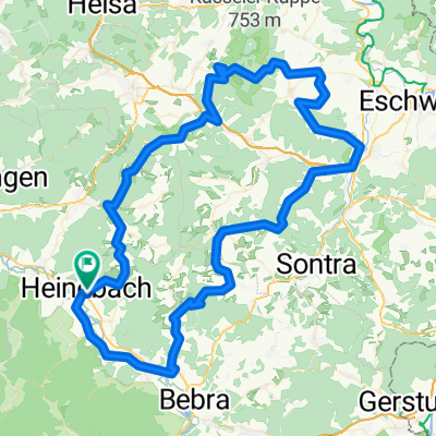
We start from the car park at the summit near Burg Ludwigsecks. Initially, it rolls quickly to the junction towards Sterkelshausen. We soon reach the solar village of Oberellenbach. Here begins a longer climb to the pass at Sandkopf. We roll into the ecological village of Licherode and continue rolling until just before the start of Wichte. Shortly before, we turn left and gently climb to the height between that village and Oberbeisheim. At a right turn at the village entrance, we go straight on (beware of oncoming traffic). Now we go under a disused railway line and take gentle climbs past the Schneidermühle mill up to the village of Rengshausen. We roll past the youth centre Beiserhaus and leave the village with a longer climb up to 10% on the ridge before Lichtenhagen. Then it descends on a winding route to Lichtenhagen and further to Oberbeisheim. We continue undulating towards Sipperhausen. Just before that, we cross the A7 motorway, which feels strange as speeds reached are like on a race track. After Sippershausen, it is mostly flat until Dickershausen. At the village entrance, we turn right onto minor roads, mostly gently climbing, continuing to Lengemannsau. Here the landscape opens up and at over 300 m above sea level we enjoy expansive views. After passing through the village, we turn left onto the L3224. From here it mostly rolls past a basalt quarry to the edge of the small town of Homberg/Efze. We follow the signposting to Mörshausen. To Mörshausen the climb is slight. After passing through the village, it climbs more steeply on the connecting road to Welferode. In the centre of Welferode we turn right towards Remsfeld. We take a small rise and then it noticeably (up to 8%) rolls towards the edge of the A7 at Remsfeld. Now we face a longer climb up to 9% to the height around Eisenkopf. Unfortunately, we also have to contend with through-traffic here. What goes up must come down, this time back down to Rengshausen. Shortly after the junction leading to the village, we leave the busy road and turn onto a paved forest/field path parallel to the L 3254 (careful with the turn as traffic speeds are fast here). Slightly uphill it leads very quietly to Hausen and then on to Ersrode. Here we rejoin the L 3254. We take one more rise then roll down to the 'white lady'. At the crossroads we go a few meters uphill to our starting point near Burg Ludwigseck.
- -:--
- Duration
- 58.9 km
- Distance
- 945 m
- Ascent
- 945 m
- Descent
- ---
- Avg. speed
- ---
- Max. altitude

Route quality
Waytypes & surfaces along the route
Waytypes
Road
24.2 km
(41 %)
Quiet road
3.5 km
(6 %)
Surfaces
Paved
41.8 km
(71 %)
Asphalt
33 km
(56 %)
Paved (undefined)
8.8 km
(15 %)
Undefined
17.1 km
(29 %)
Continue with Bikemap
Use, edit, or download this cycling route
You would like to ride Von der Burg Ludwigseck an den Rand der Schwalm or customize it for your own trip? Here is what you can do with this Bikemap route:
Free features
- Save this route as favorite or in collections
- Copy & plan your own version of this route
- Sync your route with Garmin or Wahoo
Premium features
Free trial for 3 days, or one-time payment. More about Bikemap Premium.
- Navigate this route on iOS & Android
- Export a GPX / KML file of this route
- Create your custom printout (try it for free)
- Download this route for offline navigation
Discover more Premium features.
Get Bikemap PremiumFrom our community
Other popular routes starting in Alheim
 Zick-Zack zum Alheimer mit Abstechern
- Distance
- 51.5 km
- Ascent
- 645 m
- Descent
- 653 m
- Location
- Alheim, Hesse, Germany
 home-spangenberg-kirchof-malsfeld-home
- Distance
- 48.3 km
- Ascent
- 1,096 m
- Descent
- 1,096 m
- Location
- Alheim, Hesse, Germany
 Main -> Nordsee Tag 3
- Distance
- 108.4 km
- Ascent
- 239 m
- Descent
- 343 m
- Location
- Alheim, Hesse, Germany
 Kurze Meissnerrunde
- Distance
- 102.7 km
- Ascent
- 1,185 m
- Descent
- 1,184 m
- Location
- Alheim, Hesse, Germany
 Rund um Morschen
- Distance
- 13.1 km
- Ascent
- 379 m
- Descent
- 380 m
- Location
- Alheim, Hesse, Germany
 Walters Beisetal- Mühlen - Radweg
- Distance
- 50.5 km
- Ascent
- 396 m
- Descent
- 364 m
- Location
- Alheim, Hesse, Germany
 Vitaltag 2008
- Distance
- 56.2 km
- Ascent
- 1,727 m
- Descent
- 1,601 m
- Location
- Alheim, Hesse, Germany
 Von der Burg Ludwigseck an den Rand der Schwalm
- Distance
- 58.9 km
- Ascent
- 945 m
- Descent
- 945 m
- Location
- Alheim, Hesse, Germany
Open it in the app