Wohlbach - Hoher Stein - Adorf
A cycling route starting in Schöneck, Saxony, Germany.
Overview
About this route
Osterausflug zum Hohen Stein und Skihang Erlbach/Kegelberg
- -:--
- Duration
- 36.1 km
- Distance
- 509 m
- Ascent
- 552 m
- Descent
- ---
- Avg. speed
- ---
- Avg. speed
Route quality
Waytypes & surfaces along the route
Waytypes
Track
12.4 km
(34 %)
Quiet road
11.2 km
(31 %)
Surfaces
Paved
14.6 km
(40 %)
Unpaved
15.7 km
(44 %)
Asphalt
13 km
(36 %)
Gravel
9.9 km
(27 %)
Continue with Bikemap
Use, edit, or download this cycling route
You would like to ride Wohlbach - Hoher Stein - Adorf or customize it for your own trip? Here is what you can do with this Bikemap route:
Free features
- Save this route as favorite or in collections
- Copy & plan your own version of this route
- Sync your route with Garmin or Wahoo
Premium features
Free trial for 3 days, or one-time payment. More about Bikemap Premium.
- Navigate this route on iOS & Android
- Export a GPX / KML file of this route
- Create your custom printout (try it for free)
- Download this route for offline navigation
Discover more Premium features.
Get Bikemap PremiumFrom our community
Other popular routes starting in Schöneck
- Wohlbach - Adorf - Siebenbrunn - Gunzen - Wohlbach
- Distance
- 21.8 km
- Ascent
- 264 m
- Descent
- 217 m
- Location
- Schöneck, Saxony, Germany
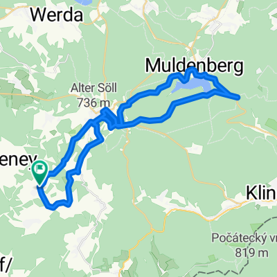
- Wohlbach-Schöneck-Talsperre Muldenberg
- Distance
- 31.6 km
- Ascent
- 536 m
- Descent
- 534 m
- Location
- Schöneck, Saxony, Germany
- Wohlbach - Adorf - Remtengrün
- Distance
- 25.9 km
- Ascent
- 369 m
- Descent
- 369 m
- Location
- Schöneck, Saxony, Germany
- best off Vogtland >>> Schilbach - Schönecl
- Distance
- 5.3 km
- Ascent
- 241 m
- Descent
- 8 m
- Location
- Schöneck, Saxony, Germany
- Wohlbach-Vogtlandarena-Klingenthal-Schöneck
- Distance
- 42 km
- Ascent
- 669 m
- Descent
- 669 m
- Location
- Schöneck, Saxony, Germany
- Wohlbach - Hoher Stein - Adorf
- Distance
- 36.1 km
- Ascent
- 509 m
- Descent
- 552 m
- Location
- Schöneck, Saxony, Germany
- Wohlbach - Erlbach - Markneukirchen - Adorf - Saalig
- Distance
- 37.4 km
- Ascent
- 468 m
- Descent
- 468 m
- Location
- Schöneck, Saxony, Germany
- Schöneck - Pressel
- Distance
- 176.9 km
- Ascent
- 333 m
- Descent
- 919 m
- Location
- Schöneck, Saxony, Germany
Open it in the app