

Cheile Dopca - Apața
A cycling route starting in Racoș, Brașov County, Romania.
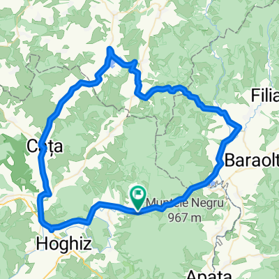
Overview
About this route
Tur plănuit și organizat de Cristi.
- -:--
- Duration
- 33.3 km
- Distance
- 482 m
- Ascent
- 467 m
- Descent
- ---
- Avg. speed
- ---
- Max. altitude

Route quality
Waytypes & surfaces along the route
Waytypes
Path
9 km
(27 %)
Track
8.3 km
(25 %)
Surfaces
Paved
7 km
(21 %)
Unpaved
23 km
(69 %)
Ground
9.7 km
(29 %)
Asphalt
7 km
(21 %)
Route highlights
Points of interest along the route

Point of interest after 0.6 km
Coloanele de bazalt

Point of interest after 1.3 km
Lacul verde-albăstrui format într-o fostă carieră.

Point of interest after 3.6 km
Cariera de scorie bazaltică sau vulcanul stins.

Point of interest after 17.5 km
Cheile Dopca

Point of interest after 20 km
Noroialî

Point of interest after 21.8 km
Push-bike zone

Point of interest after 23.3 km
Punctul cel mai înalt al traseului.
Continue with Bikemap
Use, edit, or download this cycling route
You would like to ride Cheile Dopca - Apața or customize it for your own trip? Here is what you can do with this Bikemap route:
Free features
- Save this route as favorite or in collections
- Copy & plan your own version of this route
- Sync your route with Garmin or Wahoo
Premium features
Free trial for 3 days, or one-time payment. More about Bikemap Premium.
- Navigate this route on iOS & Android
- Export a GPX / KML file of this route
- Create your custom printout (try it for free)
- Download this route for offline navigation
Discover more Premium features.
Get Bikemap PremiumFrom our community
Other popular routes starting in Racoș
 Din Racos spre Popasul pasarilor de la Sanpaul
- Distance
- 83.1 km
- Ascent
- 373 m
- Descent
- 376 m
- Location
- Racoș, Brașov County, Romania
 Coloanele de bazalt-Racos - Cheile Dopca
- Distance
- 77.1 km
- Ascent
- 601 m
- Descent
- 506 m
- Location
- Racoș, Brașov County, Romania
 racos - comana - sercaia - vladeni - codlea - brasov
- Distance
- 111.4 km
- Ascent
- 786 m
- Descent
- 708 m
- Location
- Racoș, Brașov County, Romania
 Racos-Varghis varianta 1
- Distance
- 125.6 km
- Ascent
- 463 m
- Descent
- 369 m
- Location
- Racoș, Brașov County, Romania
 Sfantu Gheorghe - Valcele - Hetea - Ariusd - Sanpetru - Brasov
- Distance
- 124.6 km
- Ascent
- 681 m
- Descent
- 664 m
- Location
- Racoș, Brașov County, Romania
 Racos-Varghis
- Distance
- 76.4 km
- Ascent
- 359 m
- Descent
- 356 m
- Location
- Racoș, Brașov County, Romania
 racos - cheile dopca - apata - feldioara - bv
- Distance
- 64.5 km
- Ascent
- 417 m
- Descent
- 334 m
- Location
- Racoș, Brașov County, Romania
 Racos - Sercaia- Rasnov
- Distance
- 92.2 km
- Ascent
- 531 m
- Descent
- 369 m
- Location
- Racoș, Brașov County, Romania
Open it in the app