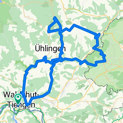
Hausberg Maxi
A cycling route starting in Koblenz, Canton of Aargau, Switzerland.
Overview
About this route
Schöne kurze aber steile Runde vor der Haustür.
- -:--
- Duration
- 48.2 km
- Distance
- 1,044 m
- Ascent
- 1,041 m
- Descent
- ---
- Avg. speed
- ---
- Avg. speed
Route quality
Waytypes & surfaces along the route
Waytypes
Road
22.1 km
(46 %)
Quiet road
12.8 km
(27 %)
Surfaces
Paved
17.3 km
(36 %)
Asphalt
17 km
(35 %)
Paved (undefined)
0.3 km
(<1 %)
Undefined
30.9 km
(64 %)
Continue with Bikemap
Use, edit, or download this cycling route
You would like to ride Hausberg Maxi or customize it for your own trip? Here is what you can do with this Bikemap route:
Free features
- Save this route as favorite or in collections
- Copy & plan your own version of this route
- Sync your route with Garmin or Wahoo
Premium features
Free trial for 3 days, or one-time payment. More about Bikemap Premium.
- Navigate this route on iOS & Android
- Export a GPX / KML file of this route
- Create your custom printout (try it for free)
- Download this route for offline navigation
Discover more Premium features.
Get Bikemap PremiumFrom our community
Other popular routes starting in Koblenz
- 1. Koblenz - Bad Säckingen (27 km)
- Distance
- 26.7 km
- Ascent
- 155 m
- Descent
- 149 m
- Location
- Koblenz, Canton of Aargau, Switzerland
- Bodenseeumfahrung
- Distance
- 312.7 km
- Ascent
- 538 m
- Descent
- 538 m
- Location
- Koblenz, Canton of Aargau, Switzerland
- Über die Berge von Schlücht- und Steinatal.
- Distance
- 105.2 km
- Ascent
- 1,923 m
- Descent
- 1,930 m
- Location
- Koblenz, Canton of Aargau, Switzerland
- Koblenz nach Trasadingen
- Distance
- 22.1 km
- Ascent
- 103 m
- Descent
- 12 m
- Location
- Koblenz, Canton of Aargau, Switzerland
- Route de l'Aar
- Distance
- 301.3 km
- Ascent
- 585 m
- Descent
- 280 m
- Location
- Koblenz, Canton of Aargau, Switzerland
- virée en foret noire/danube Constance etape 1 walshut lac de Titisee
- Distance
- 51 km
- Ascent
- 801 m
- Descent
- 263 m
- Location
- Koblenz, Canton of Aargau, Switzerland
- 2_Waldshut bis Mulhouse
- Distance
- 108.2 km
- Ascent
- 368 m
- Descent
- 440 m
- Location
- Koblenz, Canton of Aargau, Switzerland
- Rhein - Wannenbwerg - Wutach
- Distance
- 42.9 km
- Ascent
- 606 m
- Descent
- 603 m
- Location
- Koblenz, Canton of Aargau, Switzerland
Open it in the app