

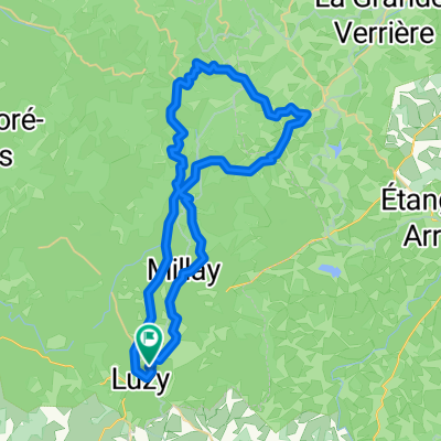
Luzy - Millay (40km)
A cycling route starting in Luzy, Bourgogne-Franche-Comté, France.
Overview
About this route
Rondje vanaf de camping La Bedure, via Millay, Poil en een leuke klim in de laatste 10 km van de rit.
Vond het een erg leuke route. Het wegdek is niet overal even goed en er ligt redelijk wat grind op (eigenlijk alle) wegen in deze streek. Net als alles in deze omgeving is niets vlak, maar alleen bij Millay is een stukje steil (circa 12%). Circa 435 hoogtemeters, afstand ca. 40 km- -:--
- Duration
- 40 km
- Distance
- 434 m
- Ascent
- 435 m
- Descent
- ---
- Avg. speed
- ---
- Max. altitude
Route quality
Waytypes & surfaces along the route
Waytypes
Road
25.1 km
(63 %)
Quiet road
9.4 km
(23 %)
Surfaces
Paved
3.7 km
(9 %)
Asphalt
3.7 km
(9 %)
Undefined
36.3 km
(91 %)
Continue with Bikemap
Use, edit, or download this cycling route
You would like to ride Luzy - Millay (40km) or customize it for your own trip? Here is what you can do with this Bikemap route:
Free features
- Save this route as favorite or in collections
- Copy & plan your own version of this route
- Sync your route with Garmin or Wahoo
Premium features
Free trial for 3 days, or one-time payment. More about Bikemap Premium.
- Navigate this route on iOS & Android
- Export a GPX / KML file of this route
- Create your custom printout (try it for free)
- Download this route for offline navigation
Discover more Premium features.
Get Bikemap PremiumFrom our community
Other popular routes starting in Luzy
 VL - Le Haut Folin
- Distance
- 80.3 km
- Ascent
- 879 m
- Descent
- 879 m
- Location
- Luzy, Bourgogne-Franche-Comté, France
 Millay - Larochemillay (46 km, 770 hm)
- Distance
- 45.8 km
- Ascent
- 639 m
- Descent
- 639 m
- Location
- Luzy, Bourgogne-Franche-Comté, France
 Rondje Millay - Uchon
- Distance
- 73.5 km
- Ascent
- 847 m
- Descent
- 847 m
- Location
- Luzy, Bourgogne-Franche-Comté, France
 Luzy - Millay (40km)
- Distance
- 40 km
- Ascent
- 434 m
- Descent
- 435 m
- Location
- Luzy, Bourgogne-Franche-Comté, France
 Rondje Mont Beuvray
- Distance
- 53.2 km
- Ascent
- 735 m
- Descent
- 735 m
- Location
- Luzy, Bourgogne-Franche-Comté, France
 Patrick 001 (63 km)
- Distance
- 62.6 km
- Ascent
- 728 m
- Descent
- 905 m
- Location
- Luzy, Bourgogne-Franche-Comté, France
 Rondje Semelay en Chides (circa 42 km, 550 hm)
- Distance
- 41.5 km
- Ascent
- 487 m
- Descent
- 487 m
- Location
- Luzy, Bourgogne-Franche-Comté, France
 rondje van af de camping
- Distance
- 48 km
- Ascent
- 669 m
- Descent
- 669 m
- Location
- Luzy, Bourgogne-Franche-Comté, France
Open it in the app