

Schdf. - Alte Steige - Adelberg - See : Rundkurs
A cycling route starting in Schorndorf, Baden-Wurttemberg, Germany.
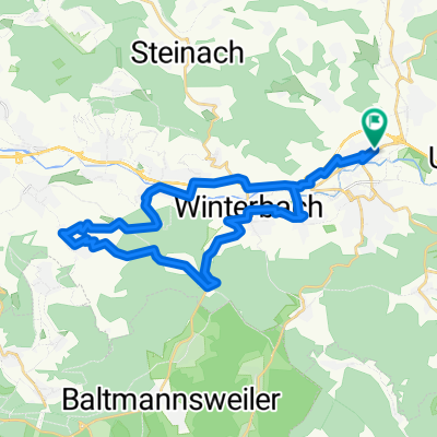
Overview
About this route
Harte Route: starke Steigung, für Mountainbike geeignet
(cloned from route 55187)- -:--
- Duration
- 12.4 km
- Distance
- 452 m
- Ascent
- 252 m
- Descent
- ---
- Avg. speed
- ---
- Max. altitude
Continue with Bikemap
Use, edit, or download this cycling route
You would like to ride Schdf. - Alte Steige - Adelberg - See : Rundkurs or customize it for your own trip? Here is what you can do with this Bikemap route:
Free features
- Save this route as favorite or in collections
- Copy & plan your own version of this route
- Sync your route with Garmin or Wahoo
Premium features
Free trial for 3 days, or one-time payment. More about Bikemap Premium.
- Navigate this route on iOS & Android
- Export a GPX / KML file of this route
- Create your custom printout (try it for free)
- Download this route for offline navigation
Discover more Premium features.
Get Bikemap PremiumFrom our community
Other popular routes starting in Schorndorf
 Rund um Schorndorf
- Distance
- 54.2 km
- Ascent
- 948 m
- Descent
- 976 m
- Location
- Schorndorf, Baden-Wurttemberg, Germany
 Schorndorf-Berglen-Gmünd
- Distance
- 80.9 km
- Ascent
- 884 m
- Descent
- 883 m
- Location
- Schorndorf, Baden-Wurttemberg, Germany
 Königliche Jagd
- Distance
- 35 km
- Ascent
- 501 m
- Descent
- 502 m
- Location
- Schorndorf, Baden-Wurttemberg, Germany
 Von Schorndorf bis Stuttgart
- Distance
- 46.4 km
- Ascent
- 235 m
- Descent
- 252 m
- Location
- Schorndorf, Baden-Wurttemberg, Germany
 Schdf-Schnait-Weinstadt-Schdf
- Distance
- 30.8 km
- Ascent
- 450 m
- Descent
- 453 m
- Location
- Schorndorf, Baden-Wurttemberg, Germany
 Schorndorf - Trinkwasser - Schönbühl
- Distance
- 32.5 km
- Ascent
- 475 m
- Descent
- 476 m
- Location
- Schorndorf, Baden-Wurttemberg, Germany
 Schdf-Schlbach-Lindental-Buhlbronn-Schdf
- Distance
- 24.2 km
- Ascent
- 282 m
- Descent
- 282 m
- Location
- Schorndorf, Baden-Wurttemberg, Germany
 Schdf-Buoch-Kleinheppach-Rems-Schdf
- Distance
- 32.9 km
- Ascent
- 354 m
- Descent
- 353 m
- Location
- Schorndorf, Baden-Wurttemberg, Germany
Open it in the app