

1er Weg Ost
A cycling route starting in Waldzell, Upper Austria, Austria.
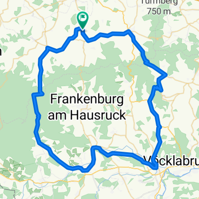
Overview
About this route
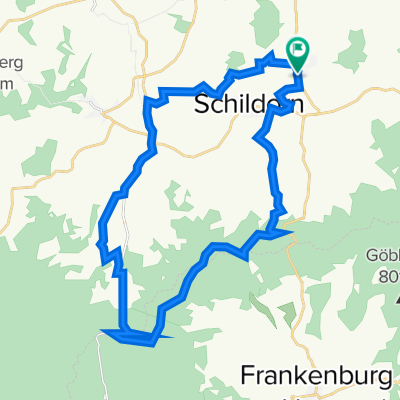
Schildorn - Turmwirt - Göblberg - Eberschwang Transmitter - Schildorn
- -:--
- Duration
- 59 km
- Distance
- 637 m
- Ascent
- 637 m
- Descent
- ---
- Avg. speed
- ---
- Max. altitude
Route quality
Waytypes & surfaces along the route
Waytypes
Track
27.7 km
(47 %)
Quiet road
7.1 km
(12 %)
Surfaces
Paved
19.5 km
(33 %)
Unpaved
28.9 km
(49 %)
Gravel
22.4 km
(38 %)
Asphalt
19.5 km
(33 %)
Continue with Bikemap
Use, edit, or download this cycling route
You would like to ride 1er Weg Ost or customize it for your own trip? Here is what you can do with this Bikemap route:
Free features
- Save this route as favorite or in collections
- Copy & plan your own version of this route
- Sync your route with Garmin or Wahoo
Premium features
Free trial for 3 days, or one-time payment. More about Bikemap Premium.
- Navigate this route on iOS & Android
- Export a GPX / KML file of this route
- Create your custom printout (try it for free)
- Download this route for offline navigation
Discover more Premium features.
Get Bikemap PremiumFrom our community
Other popular routes starting in Waldzell
 Mettmach - Schärding
- Distance
- 62.1 km
- Ascent
- 135 m
- Descent
- 323 m
- Location
- Waldzell, Upper Austria, Austria
 120er Feier Hobby 1
- Distance
- 70.3 km
- Ascent
- 690 m
- Descent
- 690 m
- Location
- Waldzell, Upper Austria, Austria
 Mettmach-Bojanhang-Stelzen
- Distance
- 26.1 km
- Ascent
- 581 m
- Descent
- 506 m
- Location
- Waldzell, Upper Austria, Austria
 Wasserdobl
- Distance
- 41 km
- Ascent
- 521 m
- Descent
- 520 m
- Location
- Waldzell, Upper Austria, Austria
 Pattigham Waldzell Schmiedwirt Sauerei KronawittenAigen Rampfen Pattigham
- Distance
- 30 km
- Ascent
- 492 m
- Descent
- 492 m
- Location
- Waldzell, Upper Austria, Austria
 1er Weg Ost
- Distance
- 59 km
- Ascent
- 637 m
- Descent
- 637 m
- Location
- Waldzell, Upper Austria, Austria
 Kobernaußerwaldrunde 50KM - 700HM
- Distance
- 50.3 km
- Ascent
- 627 m
- Descent
- 646 m
- Location
- Waldzell, Upper Austria, Austria
 Pattigham Waldzell Stelzen Amberg Wasserdop
- Distance
- 38.9 km
- Ascent
- 494 m
- Descent
- 494 m
- Location
- Waldzell, Upper Austria, Austria
Open it in the app