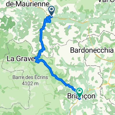
Col du Galibier via Telegraphe
A cycling route starting in Saint-Michel-de-Maurienne, Auvergne-Rh么ne-Alpes, France.
Overview
About this route
- -:--
- Duration
- 51.9 km
- Distance
- 2,223 m
- Ascent
- 1,406 m
- Descent
- ---
- Avg. speed
- 2,633 m
- Avg. speed
Route quality
Waytypes & surfaces along the route
Waytypes
Busy road
51 km
(98 %)
Access road
0.8 km
(1 %)
Surfaces
Paved
33.2 km
(64 %)
Unpaved
0.3 km
(<1 %)
Asphalt
33.2 km
(64 %)
Unpaved (undefined)
0.3 km
(<1 %)
Continue with Bikemap
Use, edit, or download this cycling route
You would like to ride Col du Galibier via Telegraphe or customize it for your own trip? Here is what you can do with this Bikemap route:
Free features
- Save this route as favorite or in collections
- Copy & plan your own version of this route
- Sync your route with Garmin or Wahoo
Premium features
Free trial for 3 days, or one-time payment. More about Bikemap Premium.
- Navigate this route on iOS & Android
- Export a GPX / KML file of this route
- Create your custom printout (try it for free)
- Download this route for offline navigation
Discover more Premium features.
Get Bikemap PremiumFrom our community
Other popular routes starting in Saint-Michel-de-Maurienne
- MONTVERNIER - TOUSSUIRE
- Distance
- 106.3 km
- Ascent
- 2,414 m
- Descent
- 2,414 m
- Location
- Saint-Michel-de-Maurienne, Auvergne-Rh么ne-Alpes, France
- Col du Galibier from St Michel de Maurienne
- Distance
- 69.6 km
- Ascent
- 2,231 m
- Descent
- 2,231 m
- Location
- Saint-Michel-de-Maurienne, Auvergne-Rh么ne-Alpes, France
- Valmeiner and Lac de Bissorte
- Distance
- 8,432.2 km
- Ascent
- 4,739 m
- Descent
- 15,443 m
- Location
- Saint-Michel-de-Maurienne, Auvergne-Rh么ne-Alpes, France
- COLL D麓 ISERAN
- Distance
- 73.6 km
- Ascent
- 2,202 m
- Descent
- 153 m
- Location
- Saint-Michel-de-Maurienne, Auvergne-Rh么ne-Alpes, France
- Day 3 St Michel-de-Maurienne to Bourg St Maurice
- Distance
- 120.1 km
- Ascent
- 2,160 m
- Descent
- 2,063 m
- Location
- Saint-Michel-de-Maurienne, Auvergne-Rh么ne-Alpes, France
- Col du Galibier severn铆 stranou
- Distance
- 81.9 km
- Ascent
- 2,351 m
- Descent
- 2,435 m
- Location
- Saint-Michel-de-Maurienne, Auvergne-Rh么ne-Alpes, France
- Col du Galibier
- Distance
- 69.7 km
- Ascent
- 2,433 m
- Descent
- 2,093 m
- Location
- Saint-Michel-de-Maurienne, Auvergne-Rh么ne-Alpes, France
- Col du Galibier Tour 2007
- Distance
- 34.9 km
- Ascent
- 2,104 m
- Descent
- 189 m
- Location
- Saint-Michel-de-Maurienne, Auvergne-Rh么ne-Alpes, France