

grenoble - huez - galibier - grenoble
A cycling route starting in Grenoble, Auvergne-Rhône-Alpes, France.
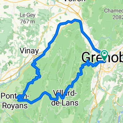
Overview
About this route
Option 2
Grenoble - cols Chamrousse - Malissol - Ornon - Huez (hotel)
Huez - Col de Sarennes - Galibier - Croix de Fer - Glandon - Mollard - Grenoble
- -:--
- Duration
- 333.9 km
- Distance
- 6,651 m
- Ascent
- 6,652 m
- Descent
- ---
- Avg. speed
- ---
- Max. altitude
Route quality
Waytypes & surfaces along the route
Waytypes
Road
50.1 km
(15 %)
Quiet road
23.4 km
(7 %)
Surfaces
Paved
190.3 km
(57 %)
Unpaved
3.3 km
(1 %)
Asphalt
190.3 km
(57 %)
Gravel
3.3 km
(1 %)
Undefined
140.2 km
(42 %)
Continue with Bikemap
Use, edit, or download this cycling route
You would like to ride grenoble - huez - galibier - grenoble or customize it for your own trip? Here is what you can do with this Bikemap route:
Free features
- Save this route as favorite or in collections
- Copy & plan your own version of this route
- Split it into stages to create a multi-day tour
- Sync your route with Garmin or Wahoo
Premium features
Free trial for 3 days, or one-time payment. More about Bikemap Premium.
- Navigate this route on iOS & Android
- Export a GPX / KML file of this route
- Create your custom printout (try it for free)
- Download this route for offline navigation
Discover more Premium features.
Get Bikemap PremiumFrom our community
Other popular routes starting in Grenoble
 Chartreuse - Col de Porte et col du Coq
- Distance
- 70.2 km
- Ascent
- 1,813 m
- Descent
- 1,814 m
- Location
- Grenoble, Auvergne-Rhône-Alpes, France
 5 March 23, Saint Laurent (with Ste)
- Distance
- 7.4 km
- Ascent
- 40 m
- Descent
- 42 m
- Location
- Grenoble, Auvergne-Rhône-Alpes, France
 grenoble - cognin-les-gorges
- Distance
- 123.1 km
- Ascent
- 2,095 m
- Descent
- 2,100 m
- Location
- Grenoble, Auvergne-Rhône-Alpes, France
 Chateau de Vizille
- Distance
- 33.1 km
- Ascent
- 300 m
- Descent
- 301 m
- Location
- Grenoble, Auvergne-Rhône-Alpes, France
 ballade test à renage avec bosse
- Distance
- 46.4 km
- Ascent
- 429 m
- Descent
- 446 m
- Location
- Grenoble, Auvergne-Rhône-Alpes, France
 Grenoble Saint Nizier retour Sassenage
- Distance
- 58.3 km
- Ascent
- 972 m
- Descent
- 972 m
- Location
- Grenoble, Auvergne-Rhône-Alpes, France
 France - Grenoble - Col de la Placette
- Distance
- 61.5 km
- Ascent
- 502 m
- Descent
- 505 m
- Location
- Grenoble, Auvergne-Rhône-Alpes, France
 Chamrousse
- Distance
- 64.8 km
- Ascent
- 1,555 m
- Descent
- 1,555 m
- Location
- Grenoble, Auvergne-Rhône-Alpes, France
Open it in the app