

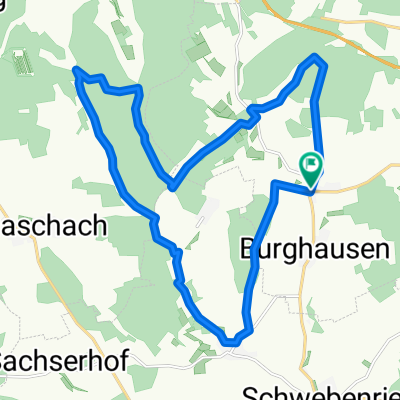
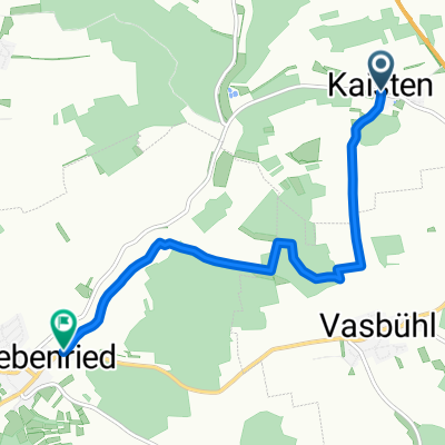
Kaisten-Schwebenried - Höhenweg
A cycling route starting in Wasserlosen, Bavaria, Germany.
Overview
About this route
Kaisten
Schwebenried über Höhenweg und Jagdhütte- -:--
- Duration
- 5.8 km
- Distance
- 74 m
- Ascent
- 135 m
- Descent
- ---
- Avg. speed
- ---
- Max. altitude
Route quality
Waytypes & surfaces along the route
Waytypes
Track
5.4 km
(93 %)
Access road
0.3 km
(5 %)
Surfaces
Paved
0.4 km
(7 %)
Unpaved
4.6 km
(79 %)
Ground
2.3 km
(40 %)
Gravel
2.3 km
(39 %)
Continue with Bikemap
Use, edit, or download this cycling route
You would like to ride Kaisten-Schwebenried - Höhenweg or customize it for your own trip? Here is what you can do with this Bikemap route:
Free features
- Save this route as favorite or in collections
- Copy & plan your own version of this route
- Sync your route with Garmin or Wahoo
Premium features
Free trial for 3 days, or one-time payment. More about Bikemap Premium.
- Navigate this route on iOS & Android
- Export a GPX / KML file of this route
- Create your custom printout (try it for free)
- Download this route for offline navigation
Discover more Premium features.
Get Bikemap PremiumFrom our community
Other popular routes starting in Wasserlosen
 Schw Sömmersdorf Geldersheim Sachs II
- Distance
- 15.7 km
- Ascent
- 83 m
- Descent
- 144 m
- Location
- Wasserlosen, Bavaria, Germany
 Solaranlage Erlasee, Schlosspark Werneck
- Distance
- 47.7 km
- Ascent
- 443 m
- Descent
- 445 m
- Location
- Wasserlosen, Bavaria, Germany
 neub. altb. windr.20km 220hm
- Distance
- 20 km
- Ascent
- 215 m
- Descent
- 215 m
- Location
- Wasserlosen, Bavaria, Germany
 NACH WERNECK
- Distance
- 15.7 km
- Ascent
- 172 m
- Descent
- 235 m
- Location
- Wasserlosen, Bavaria, Germany
 Zum Schnellert nach Straße Ohne Straßennamen
- Distance
- 12.5 km
- Ascent
- 115 m
- Descent
- 167 m
- Location
- Wasserlosen, Bavaria, Germany
 Weiherstraße 2, Wasserlosen nach Am alten Sportplatz 11, Güntersleben
- Distance
- 37.8 km
- Ascent
- 426 m
- Descent
- 409 m
- Location
- Wasserlosen, Bavaria, Germany
 Schwemmelsbach - Waigo-Arnstein u. zurück
- Distance
- 49.9 km
- Ascent
- 282 m
- Descent
- 282 m
- Location
- Wasserlosen, Bavaria, Germany
 Kaisten-Schwebenried - Höhenweg
- Distance
- 5.8 km
- Ascent
- 74 m
- Descent
- 135 m
- Location
- Wasserlosen, Bavaria, Germany
Open it in the app