

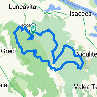
Turul Niculitelului
A cycling route starting in Rachelu, Tulcea County, Romania.
Overview
About this route
Cetatuia-Nifon - asphalt Nifon - Telita - gravel Telita - Celic Dere - Niculitel - Cocos - asphalt Man. Cocos - Cetatuia - forest 78.6 km
- -:--
- Duration
- 82.2 km
- Distance
- 748 m
- Ascent
- 748 m
- Descent
- ---
- Avg. speed
- ---
- Max. altitude
Route quality
Waytypes & surfaces along the route
Waytypes
Track
29.6 km
(36 %)
Quiet road
9.9 km
(12 %)
Surfaces
Paved
40.3 km
(49 %)
Unpaved
23.8 km
(29 %)
Asphalt
40.3 km
(49 %)
Ground
18.9 km
(23 %)
Continue with Bikemap
Use, edit, or download this cycling route
You would like to ride Turul Niculitelului or customize it for your own trip? Here is what you can do with this Bikemap route:
Free features
- Save this route as favorite or in collections
- Copy & plan your own version of this route
- Split it into stages to create a multi-day tour
- Sync your route with Garmin or Wahoo
Premium features
Free trial for 3 days, or one-time payment. More about Bikemap Premium.
- Navigate this route on iOS & Android
- Export a GPX / KML file of this route
- Create your custom printout (try it for free)
- Download this route for offline navigation
Discover more Premium features.
Get Bikemap PremiumFrom our community
Other popular routes starting in Rachelu
 Lunch Mountain Bike Ride
- Distance
- 71 km
- Ascent
- 1,318 m
- Descent
- 1,316 m
- Location
- Rachelu, Tulcea County, Romania
 Turul Niculitelului
- Distance
- 82.2 km
- Ascent
- 748 m
- Descent
- 748 m
- Location
- Rachelu, Tulcea County, Romania
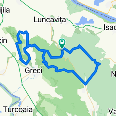
 Valea Fagilor Greci Nifon Niculitel Nifon Greci Valea Fagilor
- Distance
- 87.6 km
- Ascent
- 1,711 m
- Descent
- 1,711 m
- Location
- Rachelu, Tulcea County, Romania
 CETATUIA-TUTUIATU-DE IMPINS VAGOANE-MOROIANU-NIFON-CETATUIA
- Distance
- 38.3 km
- Ascent
- 739 m
- Descent
- 733 m
- Location
- Rachelu, Tulcea County, Romania
 Explorer MTB Challenge, Luncavita
- Distance
- 38.3 km
- Ascent
- 634 m
- Descent
- 626 m
- Location
- Rachelu, Tulcea County, Romania
 Explorer Trail Run
- Distance
- 27.7 km
- Ascent
- 509 m
- Descent
- 501 m
- Location
- Rachelu, Tulcea County, Romania
 Cetatuia- Man.Cocos- Isaccea- Galati
- Distance
- 72 km
- Ascent
- 464 m
- Descent
- 523 m
- Location
- Rachelu, Tulcea County, Romania
 Explorer MTB Challenge AER Lung
- Distance
- 67.5 km
- Ascent
- 1,511 m
- Descent
- 1,507 m
- Location
- Rachelu, Tulcea County, Romania
Open it in the app