Okolo Donnerskirchen (B11, kratší varianta)
A cycling route starting in Stotzing, Burgenland, Austria.
Overview
About this route
The cycle path is almost entirely paved, with only a short 500 m section between Neufeld and Zillingsdorf/Bergwerk being gravel. It offers long flat stretches, but also short, very steep climbs. In Zillingtal, you can connect to the B33 towards Mattersburg. From Eisenstadt, you can shorten the route by taking the road directly to Stotzing.
- -:--
- Duration
- 62.1 km
- Distance
- 466 m
- Ascent
- 470 m
- Descent
- ---
- Avg. speed
- ---
- Max. altitude
Route quality
Waytypes & surfaces along the route
Waytypes
Quiet road
21.1 km
(34 %)
Track
16.1 km
(26 %)
Surfaces
Paved
32.9 km
(53 %)
Unpaved
8.1 km
(13 %)
Asphalt
32.9 km
(53 %)
Ground
3.7 km
(6 %)
Continue with Bikemap
Use, edit, or download this cycling route
You would like to ride Okolo Donnerskirchen (B11, kratší varianta) or customize it for your own trip? Here is what you can do with this Bikemap route:
Free features
- Save this route as favorite or in collections
- Copy & plan your own version of this route
- Sync your route with Garmin or Wahoo
Premium features
Free trial for 3 days, or one-time payment. More about Bikemap Premium.
- Navigate this route on iOS & Android
- Export a GPX / KML file of this route
- Create your custom printout (try it for free)
- Download this route for offline navigation
Discover more Premium features.
Get Bikemap PremiumFrom our community
Other popular routes starting in Stotzing
Weinberggasse 10, Stotzing nach Weinberggasse 12, Stotzing- Distance
- 29.5 km
- Ascent
- 1,061 m
- Descent
- 1,064 m
- Location
- Stotzing, Burgenland, Austria
Martin 1- Distance
- 6.1 km
- Ascent
- 162 m
- Descent
- 163 m
- Location
- Stotzing, Burgenland, Austria
Leirhagb.1- Distance
- 5.5 km
- Ascent
- 217 m
- Descent
- 204 m
- Location
- Stotzing, Burgenland, Austria
Flachgraben nach Kasernenstraße- Distance
- 24.7 km
- Ascent
- 40 m
- Descent
- 140 m
- Location
- Stotzing, Burgenland, Austria
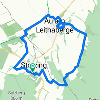
Okolo Donnerskirchen (B11)- Distance
- 79.6 km
- Ascent
- 579 m
- Descent
- 581 m
- Location
- Stotzing, Burgenland, Austria
Stotzing - Eisenstadt- Distance
- 28.5 km
- Ascent
- 164 m
- Descent
- 180 m
- Location
- Stotzing, Burgenland, Austria
Stotzing - Laa an der Thaya- Distance
- 142.9 km
- Ascent
- 454 m
- Descent
- 533 m
- Location
- Stotzing, Burgenland, Austria
Stotzing - Eisenstadt- Distance
- 28.5 km
- Ascent
- 174 m
- Descent
- 178 m
- Location
- Stotzing, Burgenland, Austria
Open it in the app


