Whittington/Guiting Power/Winchcombe
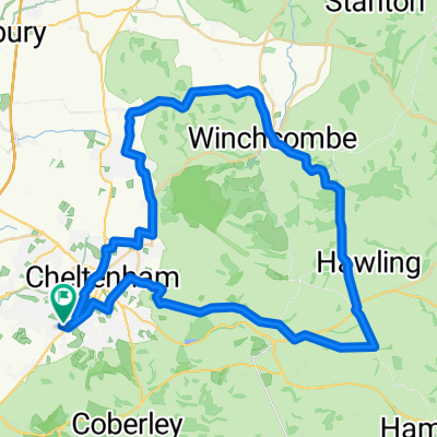
A cycling route starting in Cheltenham, England, United Kingdom.
Overview
About this route
Relatively easy climb up Tunnel Hill, but sharp climb up to Roel Gate. Fairly rolling after that, with a steep drop into Winchcombe.
- -:--
- Duration
- 44.6 km
- Distance
- 448 m
- Ascent
- 451 m
- Descent
- ---
- Avg. speed
- ---
- Max. altitude
Route quality
Waytypes & surfaces along the route
Waytypes
Road
17.4 km
(39 %)
Quiet road
12.9 km
(29 %)
Surfaces
Paved
19.2 km
(43 %)
Unpaved
0.4 km
(1 %)
Asphalt
19.2 km
(43 %)
Unpaved (undefined)
0.4 km
(1 %)
Undefined
25 km
(56 %)
Continue with Bikemap
Use, edit, or download this cycling route
You would like to ride Whittington/Guiting Power/Winchcombe or customize it for your own trip? Here is what you can do with this Bikemap route:
Free features
- Save this route as favorite or in collections
- Copy & plan your own version of this route
- Sync your route with Garmin or Wahoo
Premium features
Free trial for 3 days, or one-time payment. More about Bikemap Premium.
- Navigate this route on iOS & Android
- Export a GPX / KML file of this route
- Create your custom printout (try it for free)
- Download this route for offline navigation
Discover more Premium features.
Get Bikemap PremiumFrom our community
Other popular routes starting in Cheltenham
- Cheltenham circuit
- Distance
- 35.8 km
- Ascent
- 107 m
- Descent
- 103 m
- Location
- Cheltenham, England, United Kingdom
- CCCC Staunton B 55k
- Distance
- 55.7 km
- Ascent
- 142 m
- Descent
- 147 m
- Location
- Cheltenham, England, United Kingdom
- CCCC Chedworth fig 8 50k
- Distance
- 49.4 km
- Ascent
- 546 m
- Descent
- 543 m
- Location
- Cheltenham, England, United Kingdom
- Bagendon Bourton Winchcombe Loop
- Distance
- 79.7 km
- Ascent
- 838 m
- Descent
- 785 m
- Location
- Cheltenham, England, United Kingdom
- 11 km r
- Distance
- 11.2 km
- Ascent
- 31 m
- Descent
- 31 m
- Location
- Cheltenham, England, United Kingdom
- Scenic not too hilly cotswold bike ride
- Distance
- 26.6 km
- Ascent
- 443 m
- Descent
- 442 m
- Location
- Cheltenham, England, United Kingdom
- Cowley/Cranham/Painswick Beacon/Churchdown
- Distance
- 41.3 km
- Ascent
- 451 m
- Descent
- 451 m
- Location
- Cheltenham, England, United Kingdom
- Cotswold Ramble 1
- Distance
- 87.6 km
- Ascent
- 1,054 m
- Descent
- 1,003 m
- Location
- Cheltenham, England, United Kingdom
Open it in the app