

Asten
A cycling route starting in Flintsbach, Bavaria, Germany.
Overview
About this route
Route Description:
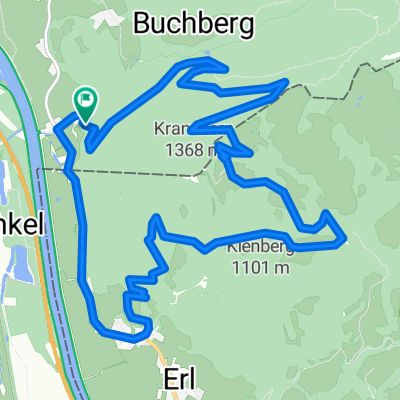
Starting from Brannenburg, the tour first follows a paved road, then climbs steeply on a gravel path. At the top, the route descends gently, first along a gravel road, then onto a little-used forest trail leading to the road at Asten. Follow this road for a short distance before turning right onto a trail; from here, the descent continues mostly on trails (S3) down to the valley. Character: The area around the Riesenkopf seems forgotten by cyclists, although it offers wonderful trails that could benefit from being better worn in. If you're lucky, you might encounter a displaying capercaillie on the tour rather than an overbearing host eyeing mountain bikers. For this reason, it's advised to avoid the inn at Asten. During the descent, there are relatively few hikers on the trail, with more appearing only below Petersberg. So don’t be alarmed if a hiker comes along.- -:--
- Duration
- 13 km
- Distance
- 734 m
- Ascent
- 734 m
- Descent
- ---
- Avg. speed
- ---
- Max. altitude

Continue with Bikemap
Use, edit, or download this cycling route
You would like to ride Asten or customize it for your own trip? Here is what you can do with this Bikemap route:
Free features
- Save this route as favorite or in collections
- Copy & plan your own version of this route
- Sync your route with Garmin or Wahoo
Premium features
Free trial for 3 days, or one-time payment. More about Bikemap Premium.
- Navigate this route on iOS & Android
- Export a GPX / KML file of this route
- Create your custom printout (try it for free)
- Download this route for offline navigation
Discover more Premium features.
Get Bikemap PremiumFrom our community
Other popular routes starting in Flintsbach
 Philosophen-Steig bei Flintsbach, Wanderung
- Distance
- 7.1 km
- Ascent
- 432 m
- Descent
- 430 m
- Location
- Flintsbach, Bavaria, Germany
 Kranzhorntrail
- Distance
- 15.5 km
- Ascent
- 854 m
- Descent
- 854 m
- Location
- Flintsbach, Bavaria, Germany
 Von Flintsbach nach Wasserburg am Inn
- Distance
- 46.1 km
- Ascent
- 123 m
- Descent
- 149 m
- Location
- Flintsbach, Bavaria, Germany
 Bergseen
- Distance
- 107.1 km
- Ascent
- 1,349 m
- Descent
- 1,349 m
- Location
- Flintsbach, Bavaria, Germany
 Bergseen
- Distance
- 107.3 km
- Ascent
- 1,352 m
- Descent
- 1,353 m
- Location
- Flintsbach, Bavaria, Germany
 Sudelfeld und Ursprungpass
- Distance
- 72.5 km
- Ascent
- 1,639 m
- Descent
- 1,642 m
- Location
- Flintsbach, Bavaria, Germany
 Von Flintsbach am Inn nach Wasserburg am Inn
- Distance
- 50.9 km
- Ascent
- 274 m
- Descent
- 257 m
- Location
- Flintsbach, Bavaria, Germany
 runde flinntsbach triathlon
- Distance
- 5.5 km
- Ascent
- 10 m
- Descent
- 8 m
- Location
- Flintsbach, Bavaria, Germany
Open it in the app