Bangkok to Hua Hin
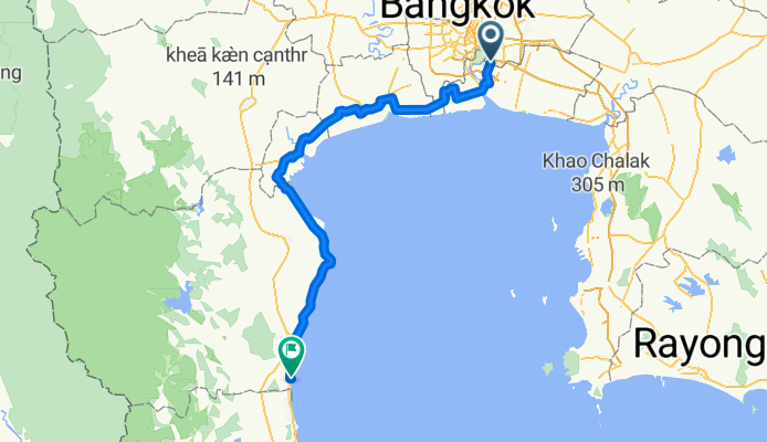
A cycling route starting in Bang Na, Bangkok, Thailand.
Overview
About this route
This is a very varied road bike route which takes you from Bearing BTS station, the most southern station on the BTS in Bangkok to the Sheraton Hotel in Hua Hin, which is a very good place to recover once you've ridden 206 km. The route avoids highways and major roads as much as possible and takes you down some fairly remote klongs and rough tracks. I rode it on a Specialised Roubaix road bike which ate the rough stuff (as it is designed to do) but a good quality road bike will have no problems. Scenery is also a plus with the very rural paddy fields in the northern sector and the salt farms on the coast east of Phetchaburi. The route also uses one ferry to cross the Chao Phraya and the pier can be accessed through a covered market but you have to look for it. The ferry avoids the need to cross the huge expressway bridge to the north.
- -:--
- Duration
- 204.6 km
- Distance
- 22 m
- Ascent
- 20 m
- Descent
- ---
- Avg. speed
- ---
- Avg. speed
Route quality
Waytypes & surfaces along the route
Waytypes
Undefined
204.6 km
(100 %)
Surfaces
Undefined
204.6 km
(100 %)
Continue with Bikemap
Use, edit, or download this cycling route
You would like to ride Bangkok to Hua Hin or customize it for your own trip? Here is what you can do with this Bikemap route:
Free features
- Save this route as favorite or in collections
- Copy & plan your own version of this route
- Sync your route with Garmin or Wahoo
Premium features
Free trial for 3 days, or one-time payment. More about Bikemap Premium.
- Navigate this route on iOS & Android
- Export a GPX / KML file of this route
- Create your custom printout (try it for free)
- Download this route for offline navigation
Discover more Premium features.
Get Bikemap PremiumFrom our community
Other popular routes starting in Bang Na
- Tambon Bang Kaeo to Kanchanaphisek Road, Tambon Bang Kaeo
- Distance
- 20.9 km
- Ascent
- 126 m
- Descent
- 125 m
- Location
- Bang Na, Bangkok, Thailand
- 24 km loop
- Distance
- 24 km
- Ascent
- 10 m
- Descent
- 12 m
- Location
- Bang Na, Bangkok, Thailand
- Thailand, Tambon Sam Rong Nua nach Sukhumvit Road
- Distance
- 12.2 km
- Ascent
- 37 m
- Descent
- 34 m
- Location
- Bang Na, Bangkok, Thailand
- Route nach Charoen Mit Alley 2
- Distance
- 13.3 km
- Ascent
- 45 m
- Descent
- 41 m
- Location
- Bang Na, Bangkok, Thailand
- ถนน เทพารักษ์ 888, ตำบลเทพารักษ์ to ตำบลเทพารักษ์
- Distance
- 54.9 km
- Ascent
- 91 m
- Descent
- 90 m
- Location
- Bang Na, Bangkok, Thailand
- 418/99 Soi Muban Casa Ville Bangna Suwannaphum, Bangkok to Sammakon 1 Soi C 4, Bangkok
- Distance
- 17.5 km
- Ascent
- 24 m
- Descent
- 22 m
- Location
- Bang Na, Bangkok, Thailand
- Bueatrium Run
- Distance
- 5 km
- Ascent
- 11 m
- Descent
- 20 m
- Location
- Bang Na, Bangkok, Thailand
- Suang Luang Group Rides
- Distance
- 0.7 km
- Ascent
- 6 m
- Descent
- 4 m
- Location
- Bang Na, Bangkok, Thailand