

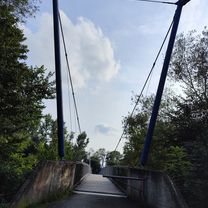
Slovenian vineyard hills
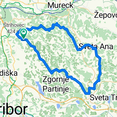
A cycling route starting in Selnica ob Muri, Občina Šentilj, Slovenia.
Overview
About this route
Route goes on western and central part of Slovenian panonian hills, full of vineyards. Little bit of ups and downs may make your heartbeat little bit faster while driving.
- -:--
- Duration
- 47 km
- Distance
- 469 m
- Ascent
- 463 m
- Descent
- ---
- Avg. speed
- ---
- Max. altitude

Route quality
Waytypes & surfaces along the route
Waytypes
Road
31.5 km
(67 %)
Quiet road
14.1 km
(30 %)
Surfaces
Paved
24.9 km
(53 %)
Unpaved
0.5 km
(1 %)
Asphalt
24.9 km
(53 %)
Ground
0.5 km
(1 %)
Undefined
21.6 km
(46 %)
Continue with Bikemap
Use, edit, or download this cycling route
You would like to ride Slovenian vineyard hills or customize it for your own trip? Here is what you can do with this Bikemap route:
Free features
- Save this route as favorite or in collections
- Copy & plan your own version of this route
- Sync your route with Garmin or Wahoo
Premium features
Free trial for 3 days, or one-time payment. More about Bikemap Premium.
- Navigate this route on iOS & Android
- Export a GPX / KML file of this route
- Create your custom printout (try it for free)
- Download this route for offline navigation
Discover more Premium features.
Get Bikemap PremiumFrom our community
Other popular routes starting in Selnica ob Muri
 Mureck Radkersburg
- Distance
- 23.7 km
- Ascent
- 31 m
- Descent
- 56 m
- Location
- Selnica ob Muri, Občina Šentilj, Slovenia
 Gravel Austria, Etappe Steiermark II
- Distance
- 107.9 km
- Ascent
- 1,287 m
- Descent
- 1,167 m
- Location
- Selnica ob Muri, Občina Šentilj, Slovenia
 Murek-Radkersburg-Murek
- Distance
- 48 km
- Ascent
- 88 m
- Descent
- 128 m
- Location
- Selnica ob Muri, Občina Šentilj, Slovenia
 Steirisch-slovenische Achter
- Distance
- 47 km
- Ascent
- 72 m
- Descent
- 71 m
- Location
- Selnica ob Muri, Občina Šentilj, Slovenia
 Slovenian vineyard hills
- Distance
- 47 km
- Ascent
- 469 m
- Descent
- 463 m
- Location
- Selnica ob Muri, Občina Šentilj, Slovenia
 AoE_Etap1
- Distance
- 83.3 km
- Ascent
- 304 m
- Descent
- 214 m
- Location
- Selnica ob Muri, Občina Šentilj, Slovenia
 Vratji Vrh, Apače nach Polički Vrh, Jarenina
- Distance
- 15.8 km
- Ascent
- 280 m
- Descent
- 280 m
- Location
- Selnica ob Muri, Občina Šentilj, Slovenia
 MU-RA-SLO-MU
- Distance
- 46.8 km
- Ascent
- 71 m
- Descent
- 71 m
- Location
- Selnica ob Muri, Občina Šentilj, Slovenia
Open it in the app