

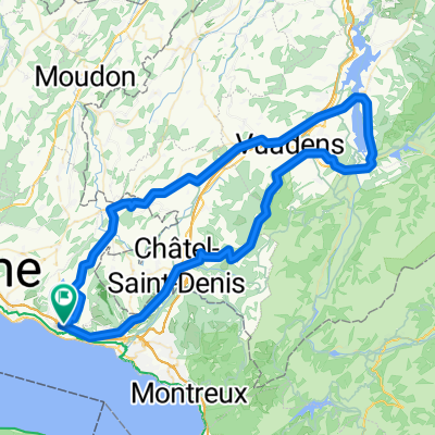
Balade en Gruyère
A cycling route starting in Chexbres, Canton of Vaud, Switzerland.
Overview
About this route
Prioritize secondary routes
- -:--
- Duration
- 91.6 km
- Distance
- 876 m
- Ascent
- 876 m
- Descent
- ---
- Avg. speed
- ---
- Max. altitude
Route quality
Waytypes & surfaces along the route
Waytypes
Road
44.9 km
(49 %)
Quiet road
24.7 km
(27 %)
Surfaces
Paved
23.8 km
(26 %)
Asphalt
22.9 km
(25 %)
Paved (undefined)
0.9 km
(1 %)
Undefined
67.8 km
(74 %)
Continue with Bikemap
Use, edit, or download this cycling route
You would like to ride Balade en Gruyère or customize it for your own trip? Here is what you can do with this Bikemap route:
Free features
- Save this route as favorite or in collections
- Copy & plan your own version of this route
- Split it into stages to create a multi-day tour
- Sync your route with Garmin or Wahoo
Premium features
Free trial for 3 days, or one-time payment. More about Bikemap Premium.
- Navigate this route on iOS & Android
- Export a GPX / KML file of this route
- Create your custom printout (try it for free)
- Download this route for offline navigation
Discover more Premium features.
Get Bikemap PremiumFrom our community
Other popular routes starting in Chexbres
 Balade en Gruyère
- Distance
- 91.6 km
- Ascent
- 876 m
- Descent
- 876 m
- Location
- Chexbres, Canton of Vaud, Switzerland
 Challenge Tour: Chexbres - Gstaad
- Distance
- 77.8 km
- Ascent
- 816 m
- Descent
- 291 m
- Location
- Chexbres, Canton of Vaud, Switzerland
 Chexbres - Interlaken
- Distance
- 121.1 km
- Ascent
- 0 m
- Descent
- 572 m
- Location
- Chexbres, Canton of Vaud, Switzerland
 ch15-04-2 Chexbres - Vevey
- Distance
- 7 km
- Ascent
- 104 m
- Descent
- 285 m
- Location
- Chexbres, Canton of Vaud, Switzerland
 Lavaux in autum
- Distance
- 22.4 km
- Ascent
- 489 m
- Descent
- 538 m
- Location
- Chexbres, Canton of Vaud, Switzerland
 Chemin de la Planta 11, Rivaz nach Avenue de Chillon 21, Veytaux
- Distance
- 15.7 km
- Ascent
- 195 m
- Descent
- 272 m
- Location
- Chexbres, Canton of Vaud, Switzerland
 Chebrex-Dent de Jaman-Chebrex
- Distance
- 28.3 km
- Ascent
- 1,186 m
- Descent
- 238 m
- Location
- Chexbres, Canton of Vaud, Switzerland
 Chexbres - Lac de Gruyère - Rathvel - Chexbres
- Distance
- 85.9 km
- Ascent
- 1,094 m
- Descent
- 1,093 m
- Location
- Chexbres, Canton of Vaud, Switzerland
Open it in the app