

Lichtenfels - 2 Klöster (Staffelberg, 14 Hlg. , Banz) nach Coburg
A cycling route starting in Lichtenfels, Bavaria, Germany.
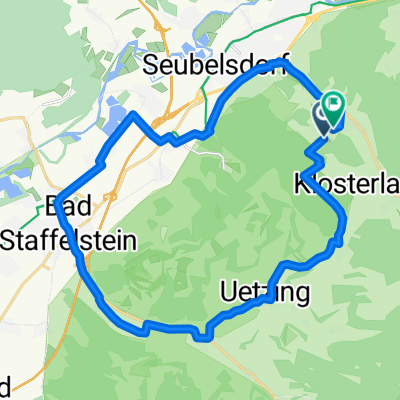
Overview
About this route
Via secondary roads from Lichtenfels through Mistelfeld and Klosterlangheim, passing Weißes Kreuz to the Staffelberg and back to Vierzehnheiligen (45 min), via the former Main ferry to the Banz Monastery (35 min) and along WS Castle Untersiemau along the Itz back to Coburg (final stop at the castle park and fortress). The climb to Weißes Kreuz is steep with fine gravel.
- -:--
- Duration
- 45.8 km
- Distance
- 630 m
- Ascent
- 602 m
- Descent
- ---
- Avg. speed
- ---
- Max. altitude
Route quality
Waytypes & surfaces along the route
Waytypes
Quiet road
14.7 km
(32 %)
Track
14.2 km
(31 %)
Surfaces
Paved
19.2 km
(42 %)
Unpaved
13.7 km
(30 %)
Asphalt
19.2 km
(42 %)
Gravel
10.5 km
(23 %)
Route highlights
Points of interest along the route
Point of interest after 13.4 km
Staffelberg mit Biergarten Staffelberg Klause
Point of interest after 18.5 km
Kloster 14 Heiligen
Point of interest after 23.3 km
Mainfähre
Point of interest after 26.4 km
ehem. Kloster Banz
Point of interest after 44.6 km
Burgschänke Veste Coburg
Continue with Bikemap
Use, edit, or download this cycling route
You would like to ride Lichtenfels - 2 Klöster (Staffelberg, 14 Hlg. , Banz) nach Coburg or customize it for your own trip? Here is what you can do with this Bikemap route:
Free features
- Save this route as favorite or in collections
- Copy & plan your own version of this route
- Sync your route with Garmin or Wahoo
Premium features
Free trial for 3 days, or one-time payment. More about Bikemap Premium.
- Navigate this route on iOS & Android
- Export a GPX / KML file of this route
- Create your custom printout (try it for free)
- Download this route for offline navigation
Discover more Premium features.
Get Bikemap PremiumFrom our community
Other popular routes starting in Lichtenfels
 Německo 2012-4.den-Main-Radweg
- Distance
- 68.4 km
- Ascent
- 163 m
- Descent
- 209 m
- Location
- Lichtenfels, Bavaria, Germany
 Lichtenfels-Kulmbach
- Distance
- 35.7 km
- Ascent
- 210 m
- Descent
- 174 m
- Location
- Lichtenfels, Bavaria, Germany
 11.07.24 Coburg-Sand am Main (7. Etappe)
- Distance
- 87 km
- Ascent
- 329 m
- Descent
- 355 m
- Location
- Lichtenfels, Bavaria, Germany
 Lichtenfels nach Bamberg
- Distance
- 38.3 km
- Ascent
- 35 m
- Descent
- 62 m
- Location
- Lichtenfels, Bavaria, Germany
 Jakobusweg LIF-BA-FO-N
- Distance
- 72.8 km
- Ascent
- 951 m
- Descent
- 960 m
- Location
- Lichtenfels, Bavaria, Germany
 Kleiner Sonntagsausflug
- Distance
- 20.2 km
- Ascent
- 412 m
- Descent
- 408 m
- Location
- Lichtenfels, Bavaria, Germany
 Oberlangheim Stublang Reundorf
- Distance
- 25.7 km
- Ascent
- 286 m
- Descent
- 286 m
- Location
- Lichtenfels, Bavaria, Germany
 test1
test1- Distance
- 16 km
- Ascent
- 232 m
- Descent
- 143 m
- Location
- Lichtenfels, Bavaria, Germany
Open it in the app