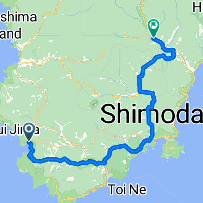
Amagi start?
A cycling route starting in Shimoda, Shizuoka, Japan.
Overview
About this route
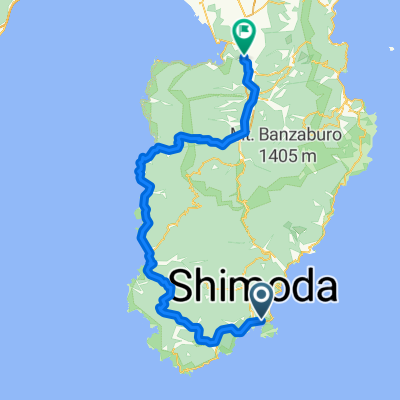
Possible start to Amagi trail ride with loop
- -:--
- Duration
- 14.5 km
- Distance
- 1,101 m
- Ascent
- 658 m
- Descent
- ---
- Avg. speed
- ---
- Max. altitude
Route quality
Waytypes & surfaces along the route
Waytypes
Track
12.6 km
(87 %)
Quiet road
1.9 km
(13 %)
Continue with Bikemap
Use, edit, or download this cycling route
You would like to ride Amagi start? or customize it for your own trip? Here is what you can do with this Bikemap route:
Free features
- Save this route as favorite or in collections
- Copy & plan your own version of this route
- Sync your route with Garmin or Wahoo
Premium features
Free trial for 3 days, or one-time payment. More about Bikemap Premium.
- Navigate this route on iOS & Android
- Export a GPX / KML file of this route
- Create your custom printout (try it for free)
- Download this route for offline navigation
Discover more Premium features.
Get Bikemap PremiumFrom our community
Other popular routes starting in Shimoda
- 石廊崎オーシャンパーク(バス), 南伊豆町 to 南伊豆町
- Distance
- 41.3 km
- Ascent
- 2,536 m
- Descent
- 2,569 m
- Location
- Shimoda, Shizuoka, Japan
- Amagi start?
- Distance
- 14.5 km
- Ascent
- 1,101 m
- Descent
- 658 m
- Location
- Shimoda, Shizuoka, Japan
- Amagi Forest road start?
- Distance
- 15.6 km
- Ascent
- 1,040 m
- Descent
- 595 m
- Location
- Shimoda, Shizuoka, Japan
- 天城越えルート
- Distance
- 53 km
- Ascent
- 1,554 m
- Descent
- 1,522 m
- Location
- Shimoda, Shizuoka, Japan
- 東伊豆コース
- Distance
- 73.5 km
- Ascent
- 1,987 m
- Descent
- 1,944 m
- Location
- Shimoda, Shizuoka, Japan
- 河津/旅師の宿 やかた-南伊豆一周
- Distance
- 120.4 km
- Ascent
- 1,371 m
- Descent
- 1,380 m
- Location
- Shimoda, Shizuoka, Japan
- 776−4, 南伊豆町 to 776−13, 南伊豆町
- Distance
- 6.8 km
- Ascent
- 48 m
- Descent
- 53 m
- Location
- Shimoda, Shizuoka, Japan
- 湯ヶ野新天城隧道到三島48.8公里
- Distance
- 48.9 km
- Ascent
- 777 m
- Descent
- 839 m
- Location
- Shimoda, Shizuoka, Japan
Open it in the app