

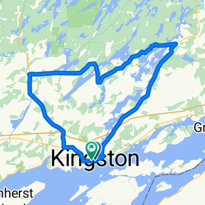
Short Ride Kingston West
A cycling route starting in Kingston, Ontario, Canada.OverviewAbout this route
Roads are calm in the evening. Most roads have a bike lane or a wide shoulder and have light traffic. There is an abundance of Mayflies in the spring.
- -:--
- Duration
- 21.8 km
- Distance
- 113 m
- Ascent
- 112 m
- Descent
- ---
- Avg. speed
- ---
- Max. altitude
Stephane Leahycreated this 11 years ago
Waytypes
Quiet road
2.8 km13 %Road
1.5 km7 %
Surfaces
Paved
21.4 km(98 %)Asphalt
21.4 km98 %Undefined
0.4 km2 %
Free features
- Save this route as favorite or in collections
- Copy & plan your own version of this route
- Sync your route with Garmin or Wahoo
Premium features
Free trial for 3 days, or one-time payment. More about Bikemap Premium.
- Navigate this route on iOS & Android
- Export a GPX / KML file of this route
- Create your custom printout (try it for free)
- Download this route for offline navigation
Discover more Premium features.
Get Bikemap Premium- Burnthills - Battersea - Sydenham - Harrowsmith
- 104.6 km
- 440 m
- 407 m
- Kingston, Ontario, Canada
- Lavernes Eatery Gananoque loop
- 63.1 km
- 248 m
- 247 m
- Kingston, Ontario, Canada
- Millwood Dr, Kingston to Millwood Dr, Kingston
- 27.7 km
- 172 m
- 171 m
- Kingston, Ontario, Canada
- Von Kingston bis Gananoque
- 38.8 km
- 263 m
- 265 m
- Kingston, Ontario, Canada
- late night bike ride
- 11.6 km
- 121 m
- 79 m
- Kingston, Ontario, Canada
- Ottawa - Rigaud
- 193.5 km
- 727 m
- 738 m
- Kingston, Ontario, Canada
- 6 Boucle Kingston
- 79.3 km
- 282 m
- 282 m
- Kingston, Ontario, Canada


Open it in the app