

TransAlp: Fischen - Gardasee Tag 3
A cycling route starting in Ischgl, Tyrol, Austria.
Overview
About this route
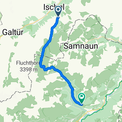
Ischgl - Sur En
Gleich in der Ortsmitte von Ischgl beginnt die sportlich Auffahrt zur Heidelberger Hütte (2264m), mitterweile ein Kultstützpunkt für hungrige Biker. Schmugglerpfade führen Sie nach der Mittagspause zum (2608) hohen Fimberpass - dem höchsten Punkt dieser Tour. Auf tollen, teilweisen anspruchsvollen Treils geht es hinunter bis nach Sur En (1112m) im Engadin. [44km 1387 hm]
- -:--
- Duration
- 36 km
- Distance
- 1,360 m
- Ascent
- 1,607 m
- Descent
- ---
- Avg. speed
- ---
- Max. altitude
Continue with Bikemap
Use, edit, or download this cycling route
You would like to ride TransAlp: Fischen - Gardasee Tag 3 or customize it for your own trip? Here is what you can do with this Bikemap route:
Free features
- Save this route as favorite or in collections
- Copy & plan your own version of this route
- Sync your route with Garmin or Wahoo
Premium features
Free trial for 3 days, or one-time payment. More about Bikemap Premium.
- Navigate this route on iOS & Android
- Export a GPX / KML file of this route
- Create your custom printout (try it for free)
- Download this route for offline navigation
Discover more Premium features.
Get Bikemap PremiumFrom our community
Other popular routes starting in Ischgl
 Ischgl - Greitspitz -Heidelberger Hütte
- Distance
- 50.6 km
- Ascent
- 2,051 m
- Descent
- 2,051 m
- Location
- Ischgl, Tyrol, Austria
 AC Dreiländertour 2011 Teil A
- Distance
- 162.2 km
- Ascent
- 3,979 m
- Descent
- 4,979 m
- Location
- Ischgl, Tyrol, Austria
 transalp e1 ischgl-idjoch
- Distance
- 38.8 km
- Ascent
- 2,362 m
- Descent
- 2,402 m
- Location
- Ischgl, Tyrol, Austria
 Ischgl - Heidelberger Hütte
- Distance
- 27.3 km
- Ascent
- 955 m
- Descent
- 684 m
- Location
- Ischgl, Tyrol, Austria
 E-Mountainbike-Fahrt E- Bike WM Ischgl
- Distance
- 25.1 km
- Ascent
- 701 m
- Descent
- 702 m
- Location
- Ischgl, Tyrol, Austria
 kl Alpenx Tag 3
- Distance
- 24.2 km
- Ascent
- 966 m
- Descent
- 996 m
- Location
- Ischgl, Tyrol, Austria
 Jeantex Tour Transalp 2007 3. Etappe
- Distance
- 163.3 km
- Ascent
- 1,827 m
- Descent
- 2,680 m
- Location
- Ischgl, Tyrol, Austria
 Ischgl 001
- Distance
- 36.4 km
- Ascent
- 3,017 m
- Descent
- 3,006 m
- Location
- Ischgl, Tyrol, Austria
Open it in the app