

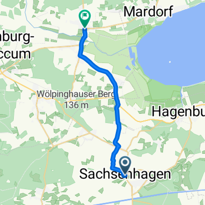
Kloster Loccum - Erlengrund
A cycling route starting in Sachsenhagen, Lower Saxony, Germany.
Overview
About this route
This tour leads to the monastery in Loccum. It is one of the best-preserved Cistercian monasteries north of the Alps and was founded in 1163. The route primarily passes through fields and meadows alongside woodland streams, fragrant wild garlic plants, disused railway tracks, romantic ponds, and the legendary Luccaburg in the monastery forest. In Loccum, there is the opportunity to enjoy ice cream or cake at the Café am Markt or at the unique Klostercafe (called Ufo or Himmelszelt). On the way back, a stop can be made at the biergarten in Erlengrund. Those who wish to skip it can continue straight instead of turning left on the L371. Follow this road for about 2 KM and turn right at the junction towards Berghol.
- -:--
- Duration
- 35.6 km
- Distance
- 154 m
- Ascent
- 151 m
- Descent
- ---
- Avg. speed
- ---
- Max. altitude
Route quality
Waytypes & surfaces along the route
Waytypes
Track
19.6 km
(55 %)
Quiet road
5.3 km
(15 %)
Surfaces
Paved
15.7 km
(44 %)
Unpaved
15 km
(42 %)
Asphalt
10.7 km
(30 %)
Gravel
10.3 km
(29 %)
Continue with Bikemap
Use, edit, or download this cycling route
You would like to ride Kloster Loccum - Erlengrund or customize it for your own trip? Here is what you can do with this Bikemap route:
Free features
- Save this route as favorite or in collections
- Copy & plan your own version of this route
- Sync your route with Garmin or Wahoo
Premium features
Free trial for 3 days, or one-time payment. More about Bikemap Premium.
- Navigate this route on iOS & Android
- Export a GPX / KML file of this route
- Create your custom printout (try it for free)
- Download this route for offline navigation
Discover more Premium features.
Get Bikemap PremiumFrom our community
Other popular routes starting in Sachsenhagen
 fehlender link
- Distance
- 12.7 km
- Ascent
- 39 m
- Descent
- 44 m
- Location
- Sachsenhagen, Lower Saxony, Germany
 Storchenroute in der Samtgemeinde Sachsenhagen
- Distance
- 30.2 km
- Ascent
- 120 m
- Descent
- 118 m
- Location
- Sachsenhagen, Lower Saxony, Germany
 Düdinghäuser Berg bis Loccumer Berg CLONED FROM ROUTE 942754
- Distance
- 28.8 km
- Ascent
- 394 m
- Descent
- 393 m
- Location
- Sachsenhagen, Lower Saxony, Germany
 Gödenstraße 6, Sachsenhagen nach Heidtorstraße 47, Rehburg-Loccum
- Distance
- 11.4 km
- Ascent
- 64 m
- Descent
- 78 m
- Location
- Sachsenhagen, Lower Saxony, Germany
 Heisterberg-Bückeberg-Harrl über den Kamm
- Distance
- 74 km
- Ascent
- 518 m
- Descent
- 520 m
- Location
- Sachsenhagen, Lower Saxony, Germany
 Sachsenhagen- Köterberg
- Distance
- 91.1 km
- Ascent
- 1,204 m
- Descent
- 775 m
- Location
- Sachsenhagen, Lower Saxony, Germany
 Leibnizring 6, Sachsenhagen nach Schaumburger Weg 49, Stadthagen
- Distance
- 17.5 km
- Ascent
- 180 m
- Descent
- 95 m
- Location
- Sachsenhagen, Lower Saxony, Germany
 Von Sachsenhagen bis Langenhagen
- Distance
- 37.4 km
- Ascent
- 53 m
- Descent
- 53 m
- Location
- Sachsenhagen, Lower Saxony, Germany
Open it in the app