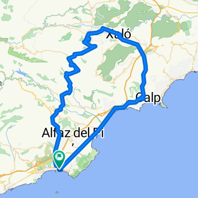
Premium Badge Download on the App Store Get it on Google Play Turn-by-turn Navigation Offline Maps Bike Type Optimized Routing Premium Maps Custom Bike Computer Export Routes Route Previews Fall Detection Premium Support

Cycling Route in Benidorm, Valencia, Spain

Confrides y Tudons

2
Open this route in the Bikemap app

Open this route in the Bikemap app

Open this route in Bikemap Web

Open this route in Bikemap Web

114 km
Distance
1671 m
Ascent
1659 m
Descent
-:-- h
Duration
-- km/h
Avg. Speed
--- m
Max. Elevation

About This Route

Una vuelta asequible en km pero con dos subidas que aunque no tengan excesiva dureza suman km de ascension...unos 35 aproximadamente.

Desde el principio de la ruta es practicamente ascendente hasta el alto de Confrides pasando cerca del bonito Castel de Guadalest.

Mas tarde se ascendera el alto Tudons que nos dejara descansar en su descenso las piernas hasta villajoyosa.


DURACION      4-5H

DIFICULTAD    ***

DEM                39X23

This cycling route is ideal for: Road bike

You will cycle on the following surfaces: Paved

Customize this cycling route with the Bikemap route planner.

Make it yours!

Did you know? You can use this route as a template in our cycling route planner if you don't wish to start from scratch. Customize it based on your needs to plan your perfect cycling tour.

Open it in the app