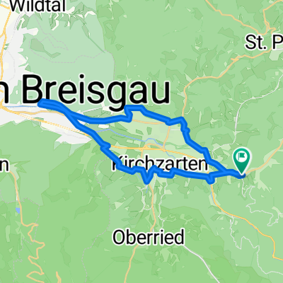
Kirchzarten-Runde
A cycling route starting in Buchenbach, Baden-Württemberg, Germany.
Overview
About this route
Kirchzarten-Sankt Märgen-Glashütte-Neukirch-Bildstöckel-Thumer-Buchenbach-Kirchzarten
- -:--
- Duration
- 52.9 km
- Distance
- 964 m
- Ascent
- 964 m
- Descent
- ---
- Avg. speed
- ---
- Avg. speed
Route quality
Waytypes & surfaces along the route
Waytypes
Busy road
32.9 km
(62 %)
Road
16.5 km
(31 %)
Surfaces
Paved
51.5 km
(97 %)
Unpaved
0.1 km
(<1 %)
Asphalt
51.5 km
(97 %)
Gravel
0.1 km
(<1 %)
Continue with Bikemap
Use, edit, or download this cycling route
You would like to ride Kirchzarten-Runde or customize it for your own trip? Here is what you can do with this Bikemap route:
Free features
- Save this route as favorite or in collections
- Copy & plan your own version of this route
- Sync your route with Garmin or Wahoo
Premium features
Free trial for 3 days, or one-time payment. More about Bikemap Premium.
- Navigate this route on iOS & Android
- Export a GPX / KML file of this route
- Create your custom printout (try it for free)
- Download this route for offline navigation
Discover more Premium features.
Get Bikemap PremiumFrom our community
Other popular routes starting in Buchenbach
- Im hinteren Eschbach
- Distance
- 34.2 km
- Ascent
- 928 m
- Descent
- 928 m
- Location
- Buchenbach, Baden-Württemberg, Germany
- Heimweg von Arbeit, alternative Route
- Distance
- 24.1 km
- Ascent
- 831 m
- Descent
- 427 m
- Location
- Buchenbach, Baden-Württemberg, Germany
- kleine Runde
- Distance
- 15.4 km
- Ascent
- 671 m
- Descent
- 698 m
- Location
- Buchenbach, Baden-Württemberg, Germany
- Kirchzarten-Runde
- Distance
- 52.9 km
- Ascent
- 964 m
- Descent
- 964 m
- Location
- Buchenbach, Baden-Württemberg, Germany
- Donnerstags-MTB-Tour
- Distance
- 44.5 km
- Ascent
- 956 m
- Descent
- 956 m
- Location
- Buchenbach, Baden-Württemberg, Germany
- Heimweg von Arbeit
- Distance
- 30.5 km
- Ascent
- 832 m
- Descent
- 371 m
- Location
- Buchenbach, Baden-Württemberg, Germany
- Titisee
- Distance
- 71.3 km
- Ascent
- 1,084 m
- Descent
- 1,084 m
- Location
- Buchenbach, Baden-Württemberg, Germany
- Präsident-Thoma-Weg
- Distance
- 44.5 km
- Ascent
- 1,221 m
- Descent
- 1,221 m
- Location
- Buchenbach, Baden-Württemberg, Germany
Open it in the app