

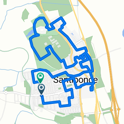
El Infierno 2014 (Ruta Corta)
A cycling route starting in Santiponce, Andalusia, Spain.
Overview
About this route
El Infierno 2014 (Short Route)
- -:--
- Duration
- 125.1 km
- Distance
- 810 m
- Ascent
- 810 m
- Descent
- ---
- Avg. speed
- ---
- Max. altitude
Route quality
Waytypes & surfaces along the route
Waytypes
Road
52.5 km
(42 %)
Cycleway
36.3 km
(29 %)
Surfaces
Paved
38.8 km
(31 %)
Unpaved
7.5 km
(6 %)
Asphalt
38.8 km
(31 %)
Ground
6.3 km
(5 %)
Continue with Bikemap
Use, edit, or download this cycling route
You would like to ride El Infierno 2014 (Ruta Corta) or customize it for your own trip? Here is what you can do with this Bikemap route:
Free features
- Save this route as favorite or in collections
- Copy & plan your own version of this route
- Split it into stages to create a multi-day tour
- Sync your route with Garmin or Wahoo
Premium features
Free trial for 3 days, or one-time payment. More about Bikemap Premium.
- Navigate this route on iOS & Android
- Export a GPX / KML file of this route
- Create your custom printout (try it for free)
- Download this route for offline navigation
Discover more Premium features.
Get Bikemap PremiumFrom our community
Other popular routes starting in Santiponce
 santiponce -coria-salteras-santiponce
- Distance
- 52.2 km
- Ascent
- 215 m
- Descent
- 212 m
- Location
- Santiponce, Andalusia, Spain
 El Infierno directo
- Distance
- 204 km
- Ascent
- 1,565 m
- Descent
- 1,565 m
- Location
- Santiponce, Andalusia, Spain
 1ª RUTA
- Distance
- 36.4 km
- Ascent
- 89 m
- Descent
- 89 m
- Location
- Santiponce, Andalusia, Spain
 CARRERA SANTIPONCE 10K
- Distance
- 10.1 km
- Ascent
- 70 m
- Descent
- 71 m
- Location
- Santiponce, Andalusia, Spain
 Vuelta a Zufre.
- Distance
- 150.4 km
- Ascent
- 1,301 m
- Descent
- 1,307 m
- Location
- Santiponce, Andalusia, Spain
 Carrera Popular 25
- Distance
- 10 km
- Ascent
- 62 m
- Descent
- 62 m
- Location
- Santiponce, Andalusia, Spain
 Camas- El Ronquillo
- Distance
- 80.2 km
- Ascent
- 765 m
- Descent
- 762 m
- Location
- Santiponce, Andalusia, Spain
 Santiponce-Arcos de la Frontera
- Distance
- 106 km
- Ascent
- 514 m
- Descent
- 335 m
- Location
- Santiponce, Andalusia, Spain
Open it in the app