

Mtb socica
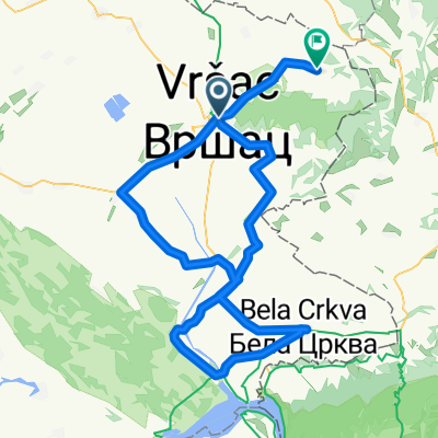
A cycling route starting in Vršac, Vojvodina, Serbia.
Overview
About this route
A
- -:--
- Duration
- 47.9 km
- Distance
- 864 m
- Ascent
- 863 m
- Descent
- ---
- Avg. speed
- ---
- Max. altitude
Continue with Bikemap
Use, edit, or download this cycling route
You would like to ride Mtb socica or customize it for your own trip? Here is what you can do with this Bikemap route:
Free features
- Save this route as favorite or in collections
- Copy & plan your own version of this route
- Sync your route with Garmin or Wahoo
Premium features
Free trial for 3 days, or one-time payment. More about Bikemap Premium.
- Navigate this route on iOS & Android
- Export a GPX / KML file of this route
- Create your custom printout (try it for free)
- Download this route for offline navigation
Discover more Premium features.
Get Bikemap PremiumFrom our community
Other popular routes starting in Vršac
 Otona Župančića 113, Gudurica to Prešernova, Гудурица
- Distance
- 22.9 km
- Ascent
- 563 m
- Descent
- 557 m
- Location
- Vršac, Vojvodina, Serbia
 giro di ćevapi 7 (2012)
- Distance
- 981.3 km
- Ascent
- 3,822 m
- Descent
- 3,829 m
- Location
- Vršac, Vojvodina, Serbia
 Circuit Vrsac
- Distance
- 42.7 km
- Ascent
- 391 m
- Descent
- 390 m
- Location
- Vršac, Vojvodina, Serbia
 Unnamed Road, Vršac to Unnamed Road, Vršac
- Distance
- 38.3 km
- Ascent
- 2,795 m
- Descent
- 2,748 m
- Location
- Vršac, Vojvodina, Serbia
 Big Gay
- Distance
- 58.1 km
- Ascent
- 32 m
- Descent
- 35 m
- Location
- Vršac, Vojvodina, Serbia
 tura la vrasc la prietenii bane si damir!
- Distance
- 20.6 km
- Ascent
- 781 m
- Descent
- 781 m
- Location
- Vršac, Vojvodina, Serbia
 Bela crkva
- Distance
- 120.2 km
- Ascent
- 227 m
- Descent
- 213 m
- Location
- Vršac, Vojvodina, Serbia
 Dealuri Vrasac
- Distance
- 43.6 km
- Ascent
- 1,115 m
- Descent
- 1,112 m
- Location
- Vršac, Vojvodina, Serbia
Open it in the app