

monmoutshire canal and brin oer tramway
A cycling route starting in Gilwern, Wales, United Kingdom.
Overview
About this route
Part of the route is over a bridal path, which is unsuited for biking. You have to walk a few km along the old tramway part.
- -:--
- Duration
- 50.8 km
- Distance
- 560 m
- Ascent
- 556 m
- Descent
- ---
- Avg. speed
- ---
- Max. altitude
Continue with Bikemap
Use, edit, or download this cycling route
You would like to ride monmoutshire canal and brin oer tramway or customize it for your own trip? Here is what you can do with this Bikemap route:
Free features
- Save this route as favorite or in collections
- Copy & plan your own version of this route
- Sync your route with Garmin or Wahoo
Premium features
Free trial for 3 days, or one-time payment. More about Bikemap Premium.
- Navigate this route on iOS & Android
- Export a GPX / KML file of this route
- Create your custom printout (try it for free)
- Download this route for offline navigation
Discover more Premium features.
Get Bikemap PremiumFrom our community
Other popular routes starting in Gilwern
 Reverse Blorenge Tumble
- Distance
- 19.5 km
- Ascent
- 600 m
- Descent
- 603 m
- Location
- Gilwern, Wales, United Kingdom
 Clydach Gorge 1
- Distance
- 17.5 km
- Ascent
- 308 m
- Descent
- 308 m
- Location
- Gilwern, Wales, United Kingdom
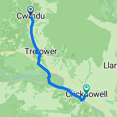 Cwmdu - Crickhowell
- Distance
- 8.4 km
- Ascent
- 78 m
- Descent
- 132 m
- Location
- Gilwern, Wales, United Kingdom
 Black mountains fun route
- Distance
- 49.4 km
- Ascent
- 1,382 m
- Descent
- 1,382 m
- Location
- Gilwern, Wales, United Kingdom
 J-45: Beacon National Park
- Distance
- 64.6 km
- Ascent
- 538 m
- Descent
- 433 m
- Location
- Gilwern, Wales, United Kingdom
 Llangattock mountain
- Distance
- 36.2 km
- Ascent
- 650 m
- Descent
- 650 m
- Location
- Gilwern, Wales, United Kingdom
 monmoutshire canal and brin oer tramway
- Distance
- 50.8 km
- Ascent
- 560 m
- Descent
- 556 m
- Location
- Gilwern, Wales, United Kingdom
 Sugar Load
- Distance
- 28.9 km
- Ascent
- 491 m
- Descent
- 491 m
- Location
- Gilwern, Wales, United Kingdom
Open it in the app