

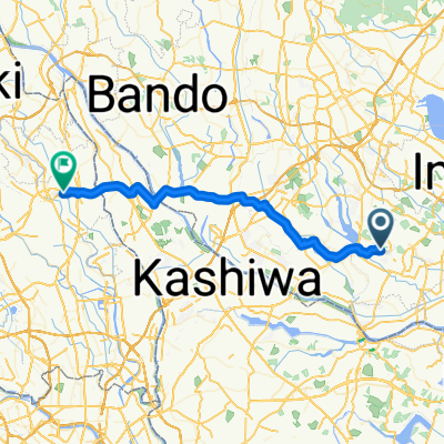
Lake Kasumigaura Loop
A cycling route starting in Ryūgasaki, Ibaraki, Japan.
Overview
About this route
This ride takes you around Lake Kasumigaura in Ibaraki Prefecture. The road around the lake has recently been updated and is a great pleasure to ride.
- -:--
- Duration
- 149.3 km
- Distance
- 98 m
- Ascent
- 98 m
- Descent
- ---
- Avg. speed
- ---
- Max. altitude
Route quality
Waytypes & surfaces along the route
Waytypes
Quiet road
100 km
(67 %)
Track
17.9 km
(12 %)
Surfaces
Paved
91.1 km
(61 %)
Asphalt
71.7 km
(48 %)
Paved (undefined)
19.4 km
(13 %)
Undefined
58.2 km
(39 %)
Continue with Bikemap
Use, edit, or download this cycling route
You would like to ride Lake Kasumigaura Loop or customize it for your own trip? Here is what you can do with this Bikemap route:
Free features
- Save this route as favorite or in collections
- Copy & plan your own version of this route
- Split it into stages to create a multi-day tour
- Sync your route with Garmin or Wahoo
Premium features
Free trial for 3 days, or one-time payment. More about Bikemap Premium.
- Navigate this route on iOS & Android
- Export a GPX / KML file of this route
- Create your custom printout (try it for free)
- Download this route for offline navigation
Discover more Premium features.
Get Bikemap PremiumFrom our community
Other popular routes starting in Ryūgasaki
 龍ケ崎市 まで735C+34, 桜川市
- Distance
- 48 km
- Ascent
- 119 m
- Descent
- 102 m
- Location
- Ryūgasaki, Ibaraki, Japan
 CCAセンチュリーライド栄~銚子~栄 2019
- Distance
- 159.1 km
- Ascent
- 1,226 m
- Descent
- 1,227 m
- Location
- Ryūgasaki, Ibaraki, Japan
 20160529_銚子センチュリーライド 2016
- Distance
- 163.8 km
- Ascent
- 1,038 m
- Descent
- 1,034 m
- Location
- Ryūgasaki, Ibaraki, Japan
 2-11, Koshiba 1-Chōme, Ryugasaki to 998-3, Ushijima, Kasukabe
- Distance
- 49.7 km
- Ascent
- 352 m
- Descent
- 362 m
- Location
- Ryūgasaki, Ibaraki, Japan
 銚子センチュリーライド2016
- Distance
- 163.8 km
- Ascent
- 1,030 m
- Descent
- 1,030 m
- Location
- Ryūgasaki, Ibaraki, Japan
 EuroVelo 6 - Atlantic-Black Sea - part Slovakia - right bank
- Distance
- 5.1 km
- Ascent
- 34 m
- Descent
- 39 m
- Location
- Ryūgasaki, Ibaraki, Japan
 De 300-280, Tone a 300-350, Tone
- Distance
- 15.6 km
- Ascent
- 62 m
- Descent
- 70 m
- Location
- Ryūgasaki, Ibaraki, Japan
 BR-Kioroshi-Noda
- Distance
- 46.5 km
- Ascent
- 75 m
- Descent
- 63 m
- Location
- Ryūgasaki, Ibaraki, Japan
Open it in the app