

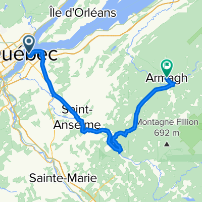
Première sortie 24 mai
A cycling route starting in Lévis, Quebec, Canada.
Overview
About this route
Check for the bike path in St-Henri
- -:--
- Duration
- 45.9 km
- Distance
- 166 m
- Ascent
- 166 m
- Descent
- ---
- Avg. speed
- ---
- Max. altitude
Route quality
Waytypes & surfaces along the route
Waytypes
Road
21.6 km
(47 %)
Cycleway
21.1 km
(46 %)
Surfaces
Paved
41.3 km
(90 %)
Asphalt
30.3 km
(66 %)
Paved (undefined)
11 km
(24 %)
Undefined
4.6 km
(10 %)
Continue with Bikemap
Use, edit, or download this cycling route
You would like to ride Première sortie 24 mai or customize it for your own trip? Here is what you can do with this Bikemap route:
Free features
- Save this route as favorite or in collections
- Copy & plan your own version of this route
- Sync your route with Garmin or Wahoo
Premium features
Free trial for 3 days, or one-time payment. More about Bikemap Premium.
- Navigate this route on iOS & Android
- Export a GPX / KML file of this route
- Create your custom printout (try it for free)
- Download this route for offline navigation
Discover more Premium features.
Get Bikemap PremiumFrom our community
Other popular routes starting in Lévis
 Beaumont - Armagh par St-Raphaël et St-Gervais
- Distance
- 100.1 km
- Ascent
- 557 m
- Descent
- 557 m
- Location
- Lévis, Quebec, Canada
 Traverse/Etchemin/Champlain
- Distance
- 36.3 km
- Ascent
- 188 m
- Descent
- 188 m
- Location
- Lévis, Quebec, Canada
 Boucle défi Pierre Lavoie 2018
- Distance
- 136.2 km
- Ascent
- 367 m
- Descent
- 360 m
- Location
- Lévis, Quebec, Canada
 15 mai 2020
- Distance
- 25.7 km
- Ascent
- 41 m
- Descent
- 42 m
- Location
- Lévis, Quebec, Canada
 De Boulevard Guillaume-Couture à Boulevard Guillaume-Couture
- Distance
- 63.6 km
- Ascent
- 348 m
- Descent
- 312 m
- Location
- Lévis, Quebec, Canada
 Lévis-Armagh Piste cyclable 95
- Distance
- 94.6 km
- Ascent
- 435 m
- Descent
- 152 m
- Location
- Lévis, Quebec, Canada
 Première sortie 24 mai
- Distance
- 45.9 km
- Ascent
- 166 m
- Descent
- 166 m
- Location
- Lévis, Quebec, Canada
 Lévis : Parcours des anses + Parc de la Rivière-Etchemin ( aller- retour )
- Distance
- 45.5 km
- Ascent
- 299 m
- Descent
- 299 m
- Location
- Lévis, Quebec, Canada
Open it in the app