

Enns - Duna - 2009 - 5.deň
A cycling route starting in Steyr, Upper Austria, Austria.
Overview
About this route
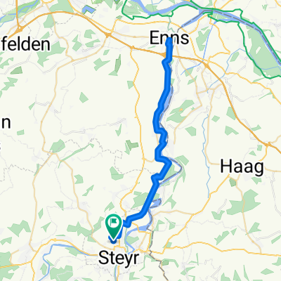
Stage: Steyr - Grein From Steyr to Enns along the marked cycle tourism route Ennsradweg, where we will connect to another marked cycle tourism route Donauradweg.
Accommodation: Camping und Herberge Grein an der Donau 4360 - Grein Donaulände 1 / Campingplatz Tel.: 07268/21230
Hungarian language info: pipper@inmail.sk
- -:--
- Duration
- 64.8 km
- Distance
- 162 m
- Ascent
- 199 m
- Descent
- ---
- Avg. speed
- ---
- Max. altitude

Route highlights
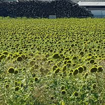
Points of interest along the route

Photo after 0.1 km

Photo after 0.4 km

Photo after 0.5 km

Photo after 2.1 km

Photo after 6.1 km

Photo after 11.1 km

Photo after 16.9 km

Photo after 20.4 km

Photo after 25.6 km

Photo after 43.2 km

Photo after 46.2 km
Continue with Bikemap
Use, edit, or download this cycling route
You would like to ride Enns - Duna - 2009 - 5.deň or customize it for your own trip? Here is what you can do with this Bikemap route:
Free features
- Save this route as favorite or in collections
- Copy & plan your own version of this route
- Sync your route with Garmin or Wahoo
Premium features
Free trial for 3 days, or one-time payment. More about Bikemap Premium.
- Navigate this route on iOS & Android
- Export a GPX / KML file of this route
- Create your custom printout (try it for free)
- Download this route for offline navigation
Discover more Premium features.
Get Bikemap PremiumFrom our community
Other popular routes starting in Steyr
 Spadenberg Special
- Distance
- 46 km
- Ascent
- 1,031 m
- Descent
- 1,027 m
- Location
- Steyr, Upper Austria, Austria
 Steyr day 1
- Distance
- 14.6 km
- Ascent
- 268 m
- Descent
- 269 m
- Location
- Steyr, Upper Austria, Austria
 Steyr - OÖ Enns mit Mündung - NÖ - Steyr
- Distance
- 73.8 km
- Ascent
- 522 m
- Descent
- 522 m
- Location
- Steyr, Upper Austria, Austria
 Steyrtalrunde
- Distance
- 27 km
- Ascent
- 434 m
- Descent
- 433 m
- Location
- Steyr, Upper Austria, Austria
 SR- Kürnberg - Glasenberg - Spadenberg - Plattenberg - Trattenbach - SR
- Distance
- 72.9 km
- Ascent
- 1,463 m
- Descent
- 1,463 m
- Location
- Steyr, Upper Austria, Austria
 SR - Steinbach/Steyr - GrüHü - Schoberstein - Trattenbach - SR
- Distance
- 68.3 km
- Ascent
- 1,196 m
- Descent
- 1,196 m
- Location
- Steyr, Upper Austria, Austria
 Joseph-Löw-Straße, Steyr nach Joseph-Löw-Straße, Steyr
- Distance
- 48.9 km
- Ascent
- 439 m
- Descent
- 437 m
- Location
- Steyr, Upper Austria, Austria
 Steyr - Schoberstein
- Distance
- 28.6 km
- Ascent
- 1,010 m
- Descent
- 349 m
- Location
- Steyr, Upper Austria, Austria
Open it in the app