

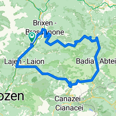
Seiseralmrunde
A cycling route starting in Feldthurns, Trentino-Alto Adige, Italy.
Overview
About this route
To the Alpe di Siusi via secondary routes
- -:--
- Duration
- 72.3 km
- Distance
- 2,062 m
- Ascent
- 2,066 m
- Descent
- ---
- Avg. speed
- ---
- Max. altitude

Route quality
Waytypes & surfaces along the route
Waytypes
Road
18.1 km
(25 %)
Quiet road
14.5 km
(20 %)
Surfaces
Paved
60.8 km
(84 %)
Asphalt
60.8 km
(84 %)
Undefined
11.6 km
(16 %)
Continue with Bikemap
Use, edit, or download this cycling route
You would like to ride Seiseralmrunde or customize it for your own trip? Here is what you can do with this Bikemap route:
Free features
- Save this route as favorite or in collections
- Copy & plan your own version of this route
- Sync your route with Garmin or Wahoo
Premium features
Free trial for 3 days, or one-time payment. More about Bikemap Premium.
- Navigate this route on iOS & Android
- Export a GPX / KML file of this route
- Create your custom printout (try it for free)
- Download this route for offline navigation
Discover more Premium features.
Get Bikemap PremiumFrom our community
Other popular routes starting in Feldthurns
 Via Haeselbrunn nach Via Haeselbrunn
- Distance
- 38.3 km
- Ascent
- 2,358 m
- Descent
- 2,356 m
- Location
- Feldthurns, Trentino-Alto Adige, Italy
 Erste Etappe Dolomiti 2012
- Distance
- 124.7 km
- Ascent
- 3,030 m
- Descent
- 3,027 m
- Location
- Feldthurns, Trentino-Alto Adige, Italy
 Passo delle Erbe
- Distance
- 48.4 km
- Ascent
- 1,380 m
- Descent
- 1,379 m
- Location
- Feldthurns, Trentino-Alto Adige, Italy
 Würzjoch - Runde
- Distance
- 66.8 km
- Ascent
- 2,021 m
- Descent
- 2,012 m
- Location
- Feldthurns, Trentino-Alto Adige, Italy
 Alte Landstraße, Velturno to Via Brigata Acqui, Trento
- Distance
- 101.7 km
- Ascent
- 798 m
- Descent
- 1,144 m
- Location
- Feldthurns, Trentino-Alto Adige, Italy
 Über Brixen zum Würzjoch - zurück über Klausen
- Distance
- 71.9 km
- Ascent
- 1,985 m
- Descent
- 1,983 m
- Location
- Feldthurns, Trentino-Alto Adige, Italy
 Sellarunde komplett
- Distance
- 128.4 km
- Ascent
- 3,205 m
- Descent
- 3,205 m
- Location
- Feldthurns, Trentino-Alto Adige, Italy
 Abschlusstour zur Zanseralm
- Distance
- 40.7 km
- Ascent
- 1,468 m
- Descent
- 1,470 m
- Location
- Feldthurns, Trentino-Alto Adige, Italy
Open it in the app