
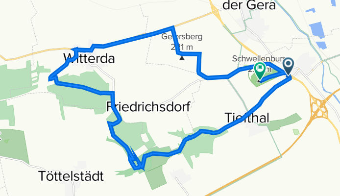
Kühnhausen - Grundmühle (Tiefthal) - Witterda
A cycling route starting in Elxleben, Free State of Thuringia, Germany.
Overview
About this route
Sehr schöne Strecke für Mountainbiker und Crossbiker. Herrliche Landschaft mit Blick über das Thüringer Becken. Auf dem Weg zur und ab der Grundmühle in Tieftal durchfährt man Waldgebiete mit Steigungen die aber zu meistern sind. Besonders schön sind die Wege mit dem ausgedrockneten Flussbett die Mountainbiker einfach mal gefaren haben müssen. Wenn 18km zu wenig sind kann die Strecke über die Fahnerischen Höhen ausdehnen
- -:--
- Duration
- 18 km
- Distance
- 256 m
- Ascent
- 215 m
- Descent
- ---
- Avg. speed
- ---
- Max. altitude
Continue with Bikemap
Use, edit, or download this cycling route
You would like to ride Kühnhausen - Grundmühle (Tiefthal) - Witterda or customize it for your own trip? Here is what you can do with this Bikemap route:
Free features
- Save this route as favorite or in collections
- Copy & plan your own version of this route
- Sync your route with Garmin or Wahoo
Premium features
Free trial for 3 days, or one-time payment. More about Bikemap Premium.
- Navigate this route on iOS & Android
- Export a GPX / KML file of this route
- Create your custom printout (try it for free)
- Download this route for offline navigation
Discover more Premium features.
Get Bikemap PremiumFrom our community
Other popular routes starting in Elxleben
 22.08.2018
- Distance
- 43.1 km
- Ascent
- 32 m
- Descent
- 43 m
- Location
- Elxleben, Free State of Thuringia, Germany
 Radrunde 26.08.17
- Distance
- 24.4 km
- Ascent
- 24 m
- Descent
- 22 m
- Location
- Elxleben, Free State of Thuringia, Germany
 04.08.20
- Distance
- 35.1 km
- Ascent
- 143 m
- Descent
- 142 m
- Location
- Elxleben, Free State of Thuringia, Germany
 Elxleben-Gebesee-Nöda-Friedrichsdorf-Elxleben
- Distance
- 42.9 km
- Ascent
- 220 m
- Descent
- 219 m
- Location
- Elxleben, Free State of Thuringia, Germany
 200km Elxleben - Artern - Freyburg - Weimar Elxleben
- Distance
- 201.7 km
- Ascent
- 948 m
- Descent
- 948 m
- Location
- Elxleben, Free State of Thuringia, Germany
 Friedhofstraße 52, Erfurt nach Friedhofstraße 52, Erfurt
- Distance
- 29.4 km
- Ascent
- 290 m
- Descent
- 296 m
- Location
- Elxleben, Free State of Thuringia, Germany
 Ausfahrt durch Erfurt 19.07.17
- Distance
- 18.2 km
- Ascent
- 27 m
- Descent
- 27 m
- Location
- Elxleben, Free State of Thuringia, Germany
 Radrunde 04.09.17
- Distance
- 18.7 km
- Ascent
- 22 m
- Descent
- 22 m
- Location
- Elxleben, Free State of Thuringia, Germany
Open it in the app