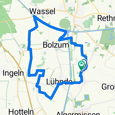
Ingeln - Anderter Bahnhof - Rundtour
A cycling route starting in Algermissen, Lower Saxony, Germany.
Overview
About this route
Ingeln - Müllingen - Wirringen - Feldmark - am Kanal lang bis zur Schleuse - Anderter Bahnhof (Biergarten) - Anderten - Andertscher Berg - Kronsberg - Feldmark - Ingeln
- -:--
- Duration
- 28.2 km
- Distance
- 99 m
- Ascent
- 101 m
- Descent
- ---
- Avg. speed
- ---
- Avg. speed
Route quality
Waytypes & surfaces along the route
Waytypes
Track
12.6 km
(45 %)
Quiet road
10.5 km
(37 %)
Surfaces
Paved
18.2 km
(65 %)
Unpaved
8.7 km
(31 %)
Asphalt
13.9 km
(49 %)
Gravel
7.9 km
(28 %)
Continue with Bikemap
Use, edit, or download this cycling route
You would like to ride Ingeln - Anderter Bahnhof - Rundtour or customize it for your own trip? Here is what you can do with this Bikemap route:
Free features
- Save this route as favorite or in collections
- Copy & plan your own version of this route
- Sync your route with Garmin or Wahoo
Premium features
Free trial for 3 days, or one-time payment. More about Bikemap Premium.
- Navigate this route on iOS & Android
- Export a GPX / KML file of this route
- Create your custom printout (try it for free)
- Download this route for offline navigation
Discover more Premium features.
Get Bikemap PremiumFrom our community
Other popular routes starting in Algermissen
- Leichte Feierabendrunde
- Distance
- 22.5 km
- Ascent
- 60 m
- Descent
- 64 m
- Location
- Algermissen, Lower Saxony, Germany
- Fasanenweg 36, Algermissen nach Neue Straße 2, Algermissen
- Distance
- 28.6 km
- Ascent
- 113 m
- Descent
- 113 m
- Location
- Algermissen, Lower Saxony, Germany
- tour1
- Distance
- 55.2 km
- Ascent
- 105 m
- Descent
- 110 m
- Location
- Algermissen, Lower Saxony, Germany
- Peine Landkreis Tour 2020
- Distance
- 124.6 km
- Ascent
- 138 m
- Descent
- 140 m
- Location
- Algermissen, Lower Saxony, Germany
- Algermissen-Hildesheim Panoramaweg
- Distance
- 42 km
- Ascent
- 305 m
- Descent
- 306 m
- Location
- Algermissen, Lower Saxony, Germany
- Lühnde Tour 90km
- Distance
- 89.1 km
- Ascent
- 509 m
- Descent
- 518 m
- Location
- Algermissen, Lower Saxony, Germany
- Rundtour Region Hannover 20.-21.5.23
- Distance
- 288.3 km
- Ascent
- 1,487 m
- Descent
- 1,487 m
- Location
- Algermissen, Lower Saxony, Germany
- Reihwiesenweg, Algermissen nach Reihwiesenweg, Algermissen
- Distance
- 57.1 km
- Ascent
- 261 m
- Descent
- 259 m
- Location
- Algermissen, Lower Saxony, Germany
Open it in the app