
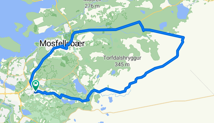
mosfellsheiði - hringur
A cycling route starting in Mosfellsbaer, Capital Region, Iceland.
Overview
About this route
mosfellsheiði - hringur hjá grjótnámu
- -:--
- Duration
- 40.7 km
- Distance
- 453 m
- Ascent
- 453 m
- Descent
- ---
- Avg. speed
- ---
- Max. altitude
Continue with Bikemap
Use, edit, or download this cycling route
You would like to ride mosfellsheiði - hringur or customize it for your own trip? Here is what you can do with this Bikemap route:
Free features
- Save this route as favorite or in collections
- Copy & plan your own version of this route
- Sync your route with Garmin or Wahoo
Premium features
Free trial for 3 days, or one-time payment. More about Bikemap Premium.
- Navigate this route on iOS & Android
- Export a GPX / KML file of this route
- Create your custom printout (try it for free)
- Download this route for offline navigation
Discover more Premium features.
Get Bikemap PremiumFrom our community
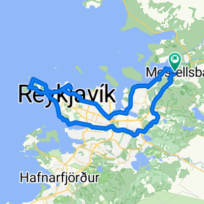
Other popular routes starting in Mosfellsbaer
 Skálafell to Skálafell
- Distance
- 1.7 km
- Ascent
- 212 m
- Descent
- 1 m
- Location
- Mosfellsbaer, Capital Region, Iceland
 Þingvellir
- Distance
- 46.1 km
- Ascent
- 474 m
- Descent
- 391 m
- Location
- Mosfellsbaer, Capital Region, Iceland
 mountain biking over Reykjafell
- Distance
- 25.5 km
- Ascent
- 509 m
- Descent
- 510 m
- Location
- Mosfellsbaer, Capital Region, Iceland
 Route to Mosfellsbær
- Distance
- 151.9 km
- Ascent
- 1,281 m
- Descent
- 1,258 m
- Location
- Mosfellsbaer, Capital Region, Iceland
 02 Iceland
- Distance
- 94 km
- Ascent
- 472 m
- Descent
- 504 m
- Location
- Mosfellsbaer, Capital Region, Iceland
 WOW Hringurinn
- Distance
- 1,420.9 km
- Ascent
- 1,945 m
- Descent
- 1,943 m
- Location
- Mosfellsbaer, Capital Region, Iceland
 Easy sunday
- Distance
- 20.5 km
- Ascent
- 177 m
- Descent
- 174 m
- Location
- Mosfellsbaer, Capital Region, Iceland
 Hringur 5.4.2014
- Distance
- 49.1 km
- Ascent
- 197 m
- Descent
- 197 m
- Location
- Mosfellsbaer, Capital Region, Iceland
Open it in the app