

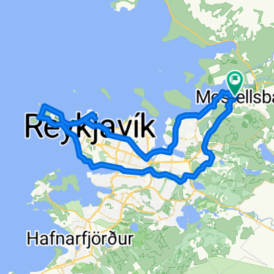
hjólað upp og niður esju
A cycling route starting in Mosfellsbaer, Capital Region, Iceland.
Overview
About this route
Bike up and down, maybe
- -:--
- Duration
- 8.7 km
- Distance
- 562 m
- Ascent
- 564 m
- Descent
- ---
- Avg. speed
- ---
- Max. altitude
Continue with Bikemap
Use, edit, or download this cycling route
You would like to ride hjólað upp og niður esju or customize it for your own trip? Here is what you can do with this Bikemap route:
Free features
- Save this route as favorite or in collections
- Copy & plan your own version of this route
- Sync your route with Garmin or Wahoo
Premium features
Free trial for 3 days, or one-time payment. More about Bikemap Premium.
- Navigate this route on iOS & Android
- Export a GPX / KML file of this route
- Create your custom printout (try it for free)
- Download this route for offline navigation
Discover more Premium features.
Get Bikemap PremiumFrom our community
Other popular routes starting in Mosfellsbaer
 hjólað upp og niður esju
- Distance
- 8.7 km
- Ascent
- 562 m
- Descent
- 564 m
- Location
- Mosfellsbaer, Capital Region, Iceland
 Hjólatúr 1.5.2014
- Distance
- 42.3 km
- Ascent
- 255 m
- Descent
- 258 m
- Location
- Mosfellsbaer, Capital Region, Iceland
 Hringur 5.4.2014
- Distance
- 49.1 km
- Ascent
- 197 m
- Descent
- 197 m
- Location
- Mosfellsbaer, Capital Region, Iceland
 WOW Hringurinn
- Distance
- 1,420.9 km
- Ascent
- 1,945 m
- Descent
- 1,943 m
- Location
- Mosfellsbaer, Capital Region, Iceland
 Þingvellir
- Distance
- 46.1 km
- Ascent
- 474 m
- Descent
- 391 m
- Location
- Mosfellsbaer, Capital Region, Iceland
 mountain biking over Reykjafell
- Distance
- 25.5 km
- Ascent
- 509 m
- Descent
- 510 m
- Location
- Mosfellsbaer, Capital Region, Iceland
 Route to Mosfellsbær
- Distance
- 151.9 km
- Ascent
- 1,281 m
- Descent
- 1,258 m
- Location
- Mosfellsbaer, Capital Region, Iceland
 Moso - Esjan -Moso
- Distance
- 27.8 km
- Ascent
- 269 m
- Descent
- 271 m
- Location
- Mosfellsbaer, Capital Region, Iceland
Open it in the app