

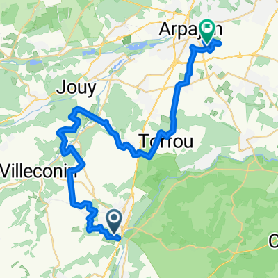
la maltournee
A cycling route starting in Étréchy, Île-de-France Region, France.
Overview
About this route
parcours etrechy camping la maltournee
- -:--
- Duration
- 84.3 km
- Distance
- 165 m
- Ascent
- 136 m
- Descent
- ---
- Avg. speed
- ---
- Max. altitude
Route quality
Waytypes & surfaces along the route
Waytypes
Busy road
67.2 km
(80 %)
Road
12 km
(14 %)
Surfaces
Paved
44 km
(52 %)
Unpaved
0.7 km
(<1 %)
Asphalt
44 km
(52 %)
Gravel
0.4 km
(<1 %)
Continue with Bikemap
Use, edit, or download this cycling route
You would like to ride la maltournee or customize it for your own trip? Here is what you can do with this Bikemap route:
Free features
- Save this route as favorite or in collections
- Copy & plan your own version of this route
- Split it into stages to create a multi-day tour
- Sync your route with Garmin or Wahoo
Premium features
Free trial for 3 days, or one-time payment. More about Bikemap Premium.
- Navigate this route on iOS & Android
- Export a GPX / KML file of this route
- Create your custom printout (try it for free)
- Download this route for offline navigation
Discover more Premium features.
Get Bikemap PremiumFrom our community
Other popular routes starting in Étréchy
 nocture du club RCN 28-29juin
- Distance
- 33.6 km
- Ascent
- 265 m
- Descent
- 317 m
- Location
- Étréchy, Île-de-France Region, France
 1er parcours essonnien
- Distance
- 58.5 km
- Ascent
- 339 m
- Descent
- 318 m
- Location
- Étréchy, Île-de-France Region, France
 3 Avenue Foch, Étréchy à 21 Rue Charles de Gaulle, Saint-Chéron
- Distance
- 14.2 km
- Ascent
- 191 m
- Descent
- 183 m
- Location
- Étréchy, Île-de-France Region, France
 9A Route du Moulin à Vent, Villeconin to 13 Route du Moulin à Vent, Villeconin
- Distance
- 3.8 km
- Ascent
- 119 m
- Descent
- 109 m
- Location
- Étréchy, Île-de-France Region, France
 7bis–15 Route du Moulin à Vent, Villeconin to 25 Grande Rue, Boissy-le-Sec
- Distance
- 4.3 km
- Ascent
- 53 m
- Descent
- 8 m
- Location
- Étréchy, Île-de-France Region, France
 st Cheron
- Distance
- 14.3 km
- Ascent
- 196 m
- Descent
- 183 m
- Location
- Étréchy, Île-de-France Region, France
 100227Etampes-Chevreuse
- Distance
- 64.9 km
- Ascent
- 480 m
- Descent
- 439 m
- Location
- Étréchy, Île-de-France Region, France
 11 Route du Moulin à Vent, Villeconin to 52 Grande Rue, Boissy-le-Sec
- Distance
- 3.8 km
- Ascent
- 103 m
- Descent
- 58 m
- Location
- Étréchy, Île-de-France Region, France
Open it in the app