
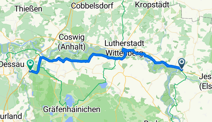
25Ag-Listerfehrda-Dessau
A cycling route starting in Elster, Saxony-Anhalt, Germany.
Overview
About this route
Next to the Elbe without any difficulty.
- -:--
- Duration
- 49.1 km
- Distance
- 52 m
- Ascent
- 62 m
- Descent
- ---
- Avg. speed
- ---
- Max. altitude

Route quality
Waytypes & surfaces along the route
Waytypes
Track
19.6 km
(40 %)
Path
10.8 km
(22 %)
Surfaces
Paved
34.9 km
(71 %)
Unpaved
2.5 km
(5 %)
Asphalt
33.4 km
(68 %)
Unpaved (undefined)
2 km
(4 %)
Continue with Bikemap
Use, edit, or download this cycling route
You would like to ride 25Ag-Listerfehrda-Dessau or customize it for your own trip? Here is what you can do with this Bikemap route:
Free features
- Save this route as favorite or in collections
- Copy & plan your own version of this route
- Sync your route with Garmin or Wahoo
Premium features
Free trial for 3 days, or one-time payment. More about Bikemap Premium.
- Navigate this route on iOS & Android
- Export a GPX / KML file of this route
- Create your custom printout (try it for free)
- Download this route for offline navigation
Discover more Premium features.
Get Bikemap PremiumFrom our community
Other popular routes starting in Elster
 Dreikönigscross
- Distance
- 46.9 km
- Ascent
- 88 m
- Descent
- 87 m
- Location
- Elster, Saxony-Anhalt, Germany
 Elbe-Rw 07: Elster - Barby
- Distance
- 97.4 km
- Ascent
- 90 m
- Descent
- 106 m
- Location
- Elster, Saxony-Anhalt, Germany
 Einzelzeitfahren im Regen
- Distance
- 48.2 km
- Ascent
- 57 m
- Descent
- 57 m
- Location
- Elster, Saxony-Anhalt, Germany
 Karfreitag
- Distance
- 100.1 km
- Ascent
- 68 m
- Descent
- 67 m
- Location
- Elster, Saxony-Anhalt, Germany
 16.07.26 Elster-Dessau Süd
- Distance
- 71.1 km
- Ascent
- 73 m
- Descent
- 79 m
- Location
- Elster, Saxony-Anhalt, Germany
 von Elster nach Steckby
- Distance
- 87.6 km
- Ascent
- 120 m
- Descent
- 130 m
- Location
- Elster, Saxony-Anhalt, Germany
 Durch den südlichen Fläming
- Distance
- 126.7 km
- Ascent
- 225 m
- Descent
- 223 m
- Location
- Elster, Saxony-Anhalt, Germany
 Elberadweg von Elster nach Dessau Rosslau
- Distance
- 52.4 km
- Ascent
- 62 m
- Descent
- 70 m
- Location
- Elster, Saxony-Anhalt, Germany
Open it in the app