
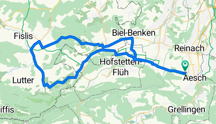
Elsass-Rundfahrt 40km
A cycling route starting in Aesch, Basel-Landschaft, Switzerland.
Overview
About this route
Aesch - Flüh - Biederthal - Wolschwiller - Oltingue - Liebenswiller - Leymen - Biel-Benken - Witterwil - Ettingen - Aesch
- -:--
- Duration
- 39.6 km
- Distance
- 313 m
- Ascent
- 313 m
- Descent
- ---
- Avg. speed
- ---
- Max. altitude

Route quality
Waytypes & surfaces along the route
Waytypes
Busy road
25.3 km
(64 %)
Road
10.8 km
(27 %)
Surfaces
Paved
11.1 km
(28 %)
Asphalt
11.1 km
(28 %)
Undefined
28.5 km
(72 %)
Continue with Bikemap
Use, edit, or download this cycling route
You would like to ride Elsass-Rundfahrt 40km or customize it for your own trip? Here is what you can do with this Bikemap route:
Free features
- Save this route as favorite or in collections
- Copy & plan your own version of this route
- Sync your route with Garmin or Wahoo
Premium features
Free trial for 3 days, or one-time payment. More about Bikemap Premium.
- Navigate this route on iOS & Android
- Export a GPX / KML file of this route
- Create your custom printout (try it for free)
- Download this route for offline navigation
Discover more Premium features.
Get Bikemap PremiumFrom our community
Other popular routes starting in Aesch
 Angenstein - Passwang (MTB)
- Distance
- 56.6 km
- Ascent
- 1,501 m
- Descent
- 1,501 m
- Location
- Aesch, Basel-Landschaft, Switzerland
 Elsass-Rundfahrt 40km
- Distance
- 39.6 km
- Ascent
- 313 m
- Descent
- 313 m
- Location
- Aesch, Basel-Landschaft, Switzerland
 Aesch (BL) - Laufen - Baettwil - Ettingen
- Distance
- 37.1 km
- Ascent
- 574 m
- Descent
- 575 m
- Location
- Aesch, Basel-Landschaft, Switzerland
 Gempen Hochwald Himmelried
- Distance
- 37 km
- Ascent
- 938 m
- Descent
- 929 m
- Location
- Aesch, Basel-Landschaft, Switzerland
 Jura-Bärgfloh Rundi
- Distance
- 61.7 km
- Ascent
- 1,640 m
- Descent
- 1,642 m
- Location
- Aesch, Basel-Landschaft, Switzerland
 Aesch - Erschwil - Nunningerberg - Gempen - Aesch
- Distance
- 57.5 km
- Ascent
- 1,627 m
- Descent
- 1,424 m
- Location
- Aesch, Basel-Landschaft, Switzerland
 Aesch, Reigoldswil, Waldenburg, Balsthal, Oensingen, Olten, Läufelfingen, Sissach, Pratteln, Münchenstein, Aesch
- Distance
- 114 km
- Ascent
- 1,030 m
- Descent
- 1,030 m
- Location
- Aesch, Basel-Landschaft, Switzerland
 mb route aesch
- Distance
- 43.2 km
- Ascent
- 753 m
- Descent
- 753 m
- Location
- Aesch, Basel-Landschaft, Switzerland
Open it in the app