

2014-05-24 janow lub, frampol
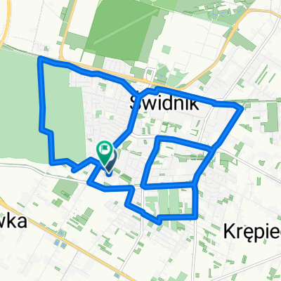
A cycling route starting in Świdnik, Lublin Voivodeship, Poland.
Overview
About this route
24.05.2014 swidnik - janow lubelski - frampol - swidnik
- -:--
- Duration
- 186.1 km
- Distance
- 397 m
- Ascent
- 390 m
- Descent
- ---
- Avg. speed
- ---
- Max. altitude
Route quality
Waytypes & surfaces along the route
Waytypes
Road
72.6 km
(39 %)
Quiet road
27.9 km
(15 %)
Surfaces
Paved
150.8 km
(81 %)
Unpaved
9.3 km
(5 %)
Asphalt
148.9 km
(80 %)
Ground
5.6 km
(3 %)
Continue with Bikemap
Use, edit, or download this cycling route
You would like to ride 2014-05-24 janow lub, frampol or customize it for your own trip? Here is what you can do with this Bikemap route:
Free features
- Save this route as favorite or in collections
- Copy & plan your own version of this route
- Split it into stages to create a multi-day tour
- Sync your route with Garmin or Wahoo
Premium features
Free trial for 3 days, or one-time payment. More about Bikemap Premium.
- Navigate this route on iOS & Android
- Export a GPX / KML file of this route
- Create your custom printout (try it for free)
- Download this route for offline navigation
Discover more Premium features.
Get Bikemap PremiumFrom our community
Other popular routes starting in Świdnik
 petla Swidnik - Lasy Kozłowieckie
- Distance
- 59.5 km
- Ascent
- 208 m
- Descent
- 208 m
- Location
- Świdnik, Lublin Voivodeship, Poland
 Spokojna jazda
- Distance
- 18.1 km
- Ascent
- 158 m
- Descent
- 175 m
- Location
- Świdnik, Lublin Voivodeship, Poland
 Olimpijczyków, Krępiec do Olimpijczyków, Krępiec
- Distance
- 53 km
- Ascent
- 266 m
- Descent
- 282 m
- Location
- Świdnik, Lublin Voivodeship, Poland
 Kolonia Świdnik Mały 62, Wólka do Kolonia Świdnik Mały 62, Wólka
- Distance
- 14.3 km
- Ascent
- 208 m
- Descent
- 210 m
- Location
- Świdnik, Lublin Voivodeship, Poland
 Olimpijczyków, Krępiec do Olimpijczyków, Krępiec
- Distance
- 28.1 km
- Ascent
- 142 m
- Descent
- 140 m
- Location
- Świdnik, Lublin Voivodeship, Poland
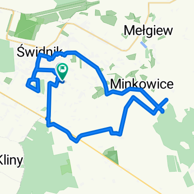
 Olimpijczyków, Świdnik do Olimpijczyków, Krępiec
- Distance
- 35.1 km
- Ascent
- 239 m
- Descent
- 235 m
- Location
- Świdnik, Lublin Voivodeship, Poland
 PoleskiParkNarodowy_PierwszyDzien
- Distance
- 67.7 km
- Ascent
- 43 m
- Descent
- 81 m
- Location
- Świdnik, Lublin Voivodeship, Poland
 Wokół lotniska w Świdniku
- Distance
- 20.6 km
- Ascent
- 70 m
- Descent
- 71 m
- Location
- Świdnik, Lublin Voivodeship, Poland
Open it in the app