
Oberhammersbach
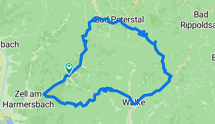
A cycling route starting in Oberharmersbach, Baden-Wurttemberg, Germany.
Overview
About this route
wonderful
- -:--
- Duration
- 50.9 km
- Distance
- 1,207 m
- Ascent
- 1,212 m
- Descent
- ---
- Avg. speed
- ---
- Max. altitude

Route quality
Waytypes & surfaces along the route
Waytypes
Road
10.2 km
(20 %)
Quiet road
5.1 km
(10 %)
Surfaces
Paved
38.7 km
(76 %)
Unpaved
1 km
(2 %)
Asphalt
38.7 km
(76 %)
Gravel
1 km
(2 %)
Undefined
11.2 km
(22 %)
Continue with Bikemap
Use, edit, or download this cycling route
You would like to ride Oberhammersbach or customize it for your own trip? Here is what you can do with this Bikemap route:
Free features
- Save this route as favorite or in collections
- Copy & plan your own version of this route
- Sync your route with Garmin or Wahoo
Premium features
Free trial for 3 days, or one-time payment. More about Bikemap Premium.
- Navigate this route on iOS & Android
- Export a GPX / KML file of this route
- Create your custom printout (try it for free)
- Download this route for offline navigation
Discover more Premium features.
Get Bikemap PremiumFrom our community
Other popular routes starting in Oberharmersbach
 Glaswaldsee
- Distance
- 33.9 km
- Ascent
- 740 m
- Descent
- 1,101 m
- Location
- Oberharmersbach, Baden-Wurttemberg, Germany
 Zell - Oberharmersbach - Nordrach Kolonie
- Distance
- 32.5 km
- Ascent
- 564 m
- Descent
- 564 m
- Location
- Oberharmersbach, Baden-Wurttemberg, Germany
 Hinterhambach Radtour
- Distance
- 16.3 km
- Ascent
- 378 m
- Descent
- 376 m
- Location
- Oberharmersbach, Baden-Wurttemberg, Germany
 Rundkurs Mittelschwazwald
- Distance
- 66.2 km
- Ascent
- 1,521 m
- Descent
- 1,521 m
- Location
- Oberharmersbach, Baden-Wurttemberg, Germany
 Unterharmersbach - Brandenkopf - Oberharmersbach
- Distance
- 22.3 km
- Ascent
- 741 m
- Descent
- 741 m
- Location
- Oberharmersbach, Baden-Wurttemberg, Germany
 Zell nach Bottenau
- Distance
- 27.7 km
- Ascent
- 626 m
- Descent
- 664 m
- Location
- Oberharmersbach, Baden-Wurttemberg, Germany
 Tour vom Langenberg nach Hohberg.
- Distance
- 38.8 km
- Ascent
- 853 m
- Descent
- 1,221 m
- Location
- Oberharmersbach, Baden-Wurttemberg, Germany
 Etappenweg Ferienlandschaft Mittlerer Schwarzwald - vom Brandenkopf nach Oberharmersbach
- Distance
- 16.5 km
- Ascent
- 648 m
- Descent
- 516 m
- Location
- Oberharmersbach, Baden-Wurttemberg, Germany
Open it in the app