

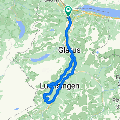
Kurze Rundstrecke mit steinigem Singletrail
A cycling route starting in Oberurnen, Canton of Glarus, Switzerland.
Overview
About this route
Pleasant singletrack trail for advanced riders. There is gravel on the path, but no high drops or steps. The tour can also be shortened by turning directly left at the first fire pit.
- -:--
- Duration
- 7.6 km
- Distance
- 327 m
- Ascent
- 325 m
- Descent
- ---
- Avg. speed
- ---
- Max. altitude
Route quality
Waytypes & surfaces along the route
Waytypes
Track
3.8 km
(50 %)
Quiet road
2.6 km
(34 %)
Surfaces
Paved
2.8 km
(37 %)
Unpaved
4.1 km
(54 %)
Asphalt
2.8 km
(37 %)
Loose gravel
2.2 km
(29 %)
Continue with Bikemap
Use, edit, or download this cycling route
You would like to ride Kurze Rundstrecke mit steinigem Singletrail or customize it for your own trip? Here is what you can do with this Bikemap route:
Free features
- Save this route as favorite or in collections
- Copy & plan your own version of this route
- Sync your route with Garmin or Wahoo
Premium features
Free trial for 3 days, or one-time payment. More about Bikemap Premium.
- Navigate this route on iOS & Android
- Export a GPX / KML file of this route
- Create your custom printout (try it for free)
- Download this route for offline navigation
Discover more Premium features.
Get Bikemap PremiumFrom our community
Other popular routes starting in Oberurnen
 Vordere Sonnenalp 7, Näfels nach Alte Landstrasse 26, Oberurnen
- Distance
- 11.1 km
- Ascent
- 28 m
- Descent
- 900 m
- Location
- Oberurnen, Canton of Glarus, Switzerland
 Näfels-Lenzerheide
- Distance
- 88.1 km
- Ascent
- 1,239 m
- Descent
- 189 m
- Location
- Oberurnen, Canton of Glarus, Switzerland
 Pragel - Klausen
- Distance
- 141.5 km
- Ascent
- 2,580 m
- Descent
- 2,581 m
- Location
- Oberurnen, Canton of Glarus, Switzerland
 Pragelpass
- Distance
- 114.4 km
- Ascent
- 2,897 m
- Descent
- 2,898 m
- Location
- Oberurnen, Canton of Glarus, Switzerland
 CH-Ost: Oberurnen - Kerenzerberg - Flumserberg
- Distance
- 41.4 km
- Ascent
- 1,283 m
- Descent
- 389 m
- Location
- Oberurnen, Canton of Glarus, Switzerland
 Kurze Rundstrecke mit steinigem Singletrail
- Distance
- 7.6 km
- Ascent
- 327 m
- Descent
- 325 m
- Location
- Oberurnen, Canton of Glarus, Switzerland
 Oberurnen-Braunwald ret..gpx
- Distance
- 59.3 km
- Ascent
- 1,125 m
- Descent
- 1,124 m
- Location
- Oberurnen, Canton of Glarus, Switzerland
 Dreitagestour Schweiz, Tag 2
- Distance
- 100 km
- Ascent
- 1,373 m
- Descent
- 1,329 m
- Location
- Oberurnen, Canton of Glarus, Switzerland
Open it in the app