

NordTour_Rundfahrt
A cycling route starting in Tegel, State of Berlin, Germany.
Overview
About this route
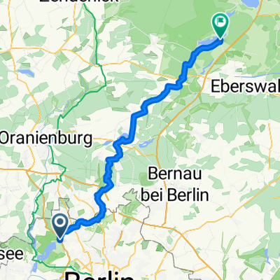
S-Bhf. Schulzendorf > Stolpe > Hennigsdorf > Aalemann Ufer > Heiligen See > Tegel > S-Bhf. Tegel
- -:--
- Duration
- 36.4 km
- Distance
- 103 m
- Ascent
- 97 m
- Descent
- ---
- Avg. speed
- ---
- Max. altitude

Route quality
Waytypes & surfaces along the route
Waytypes
Track
11.3 km
(31 %)
Path
10.2 km
(28 %)
Surfaces
Paved
25.8 km
(71 %)
Unpaved
7.3 km
(20 %)
Asphalt
24.4 km
(67 %)
Ground
4.4 km
(12 %)
Route highlights
Points of interest along the route
Point of interest after 1.6 km
zum alten Fritz Biergarten
Point of interest after 5.1 km
Strandbad Tegeler See
Point of interest after 7 km
Fähre von Spandau nach Tegel
Point of interest after 7.3 km
zum Fährhaus Biergarten
Point of interest after 9.3 km
Bürgerablage Strand / Badestelle
Point of interest after 21.6 km
Autobahn Übergang
Point of interest after 23.8 km
Marina Havelbaude Biergarten
Continue with Bikemap
Use, edit, or download this cycling route
You would like to ride NordTour_Rundfahrt or customize it for your own trip? Here is what you can do with this Bikemap route:
Free features
- Save this route as favorite or in collections
- Copy & plan your own version of this route
- Sync your route with Garmin or Wahoo
Premium features
Free trial for 3 days, or one-time payment. More about Bikemap Premium.
- Navigate this route on iOS & Android
- Export a GPX / KML file of this route
- Create your custom printout (try it for free)
- Download this route for offline navigation
Discover more Premium features.
Get Bikemap PremiumFrom our community
Other popular routes starting in Tegel
 MTB Tour: Tegel > Werbellinsee
- Distance
- 64.8 km
- Ascent
- 167 m
- Descent
- 148 m
- Location
- Tegel, State of Berlin, Germany
 Freienhagen
- Distance
- 89.2 km
- Ascent
- 128 m
- Descent
- 128 m
- Location
- Tegel, State of Berlin, Germany
 MTB Tour: Tegel > Eberswalde modified Tegel>Werbellinsee
- Distance
- 97.2 km
- Ascent
- 201 m
- Descent
- 199 m
- Location
- Tegel, State of Berlin, Germany
 Kurze Radrunde durch Berlin
- Distance
- 2.1 km
- Ascent
- 24 m
- Descent
- 19 m
- Location
- Tegel, State of Berlin, Germany
 NordTour_Rundfahrt
- Distance
- 36.4 km
- Ascent
- 103 m
- Descent
- 97 m
- Location
- Tegel, State of Berlin, Germany
 Tegel 5, Rad und Geschichte
- Distance
- 22.2 km
- Ascent
- 84 m
- Descent
- 84 m
- Location
- Tegel, State of Berlin, Germany
 BAT Tegel, Siemensstadt, Havelchaussee, Spandau, Henningsdorf
- Distance
- 54 km
- Ascent
- 194 m
- Descent
- 193 m
- Location
- Tegel, State of Berlin, Germany
 2009 Sonntagstour Tegel ->Nordwärts Landstrasse
- Distance
- 74.9 km
- Ascent
- 148 m
- Descent
- 153 m
- Location
- Tegel, State of Berlin, Germany
Open it in the app